Crosmières geodata
Crosmières (Pays de la Loire) is a populated place; located in France in Europe/Paris (GMT+2) time zone. With population of 739 people, there are 11303 cities with bigger population in this country. Compared to other cities in France, 54.9% of cities are located further ↓South; 79.2% of cities are located further →East and 77.3% of cities have higher elevation than Crosmières. Note1
Administrative division(s):
- Level 1: Pays de la Loire
- Level 2: Sarthe
- Level 3: Arrondissement de La Flèche
- Level 4: Crosmières


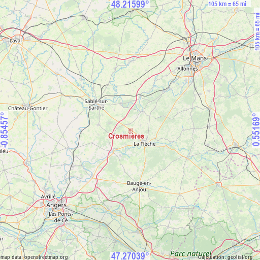
Crosmières GPS coordinates[2]
47° 44' 43.224" North, 0° 9' 5.184" West
| Map corner | latitude | longitude |
|---|---|---|
| Upper-left | 48.21599°, | -0.85457° |
| Center: | 47.74534°, | -0.15144° |
| Lower-right: | 47.27039°, | 0.55169° |
| Map W x H: | 105.1×105.1 km | = 65.3×65.3mi |
| max Lat: | 51.07786° ⇑45.1% North |
| Crosmières: | 47.74534° |
| min Lat: | ⇓54.9% South 41.3874° |
| min Long | Crosmières | max Long |
| -5.08615° | -0.15144° | 9.52242° |
| W 20.8%⇐ | ⇒79.2% E |
Elevation
Elevation of Crosmières is 61 m = 200 ft, and this is 132.7 m = 435 ft below average elevation for this country.
| Max E: |
2333 m = 7654 ft | 77.3% |
| Avg. | 193.7 m = 635 ft | |
| Crosmières | 61 m = 200 ft | |
Min E: |
-1 m = -3 ft | 22.7% |
See also: France elevation on elevation.city.
Geographical zone
Crosmières is located in North temperate zone (between Tropic of Cancer and the Arctic Circle). Distance of this North polar circle is 2092.4 km =1300.2 mi to North.| Distance of | km | miles | from Crosmières |
|---|---|---|---|
| North Pole | 4698.3 | 2919.4 | to North |
| Arctic Circle | 2092.4 | 1300.2 | to North |
| Tropic Cancer | 2702.9 | 1679.5 | to South |
| Equator | 5308.8 | 3298.7 | to South |


Nearby cities:
15 places around Crosmières: (largest is in red/bold)
• Bazouges-sur-le-Loir
6.4 km =4 mi,  191°
191°
• Clermont-Créans
10.7 km =6.6 mi,  106°
106°
• Courtillers
12.8 km =8 mi,  298°
298°
• Cré-sur-Loir
7.6 km =4.7 mi,  183°
183°
• Durtal
10.2 km =6.3 mi,  217°
217°
• Fougeré
13.1 km =8.1 mi, 178°
• La Flèche
7.7 km =4.8 mi,  132°
132°
• Les Rairies
11.2 km =7 mi,  201°
201°
• Louailles
9.1 km =5.7 mi, 304°
• Malicorne-sur-Sarthe
9.2 km =5.7 mi,  34°
34°
• Mareil-sur-Loir
12.6 km =7.8 mi, 105°
• Parcé-sur-Sarthe
11.5 km =7.1 mi,  341°
341°
• Précigné
13.2 km =8.2 mi,  280°
280°
• Villaines-sous-Malicorne
4.4 km =2.7 mi,  63°
63°
• Vion
10.5 km =6.5 mi,  321°
321°
Sources, notices
• [Note1] Compared only with cities in France existing in our database
• [Src1] Map data: © OpenStreetMap contributors (CC-BY-SA)
• [Src2] Other city data from geonames.org with taken over terms of usage.
• [Src3] Geographical zone / Annual Mean Temperature by Robert A. Rohde @ Wikipedia
