La Suze-sur-Sarthe geodata
La Suze-sur-Sarthe (Pays de la Loire) is a populated place; located in France in Europe/Paris (GMT+2) time zone. With population of 3,767 people, there are 2605 cities with bigger population in this country. Compared to other cities in France, 57.3% of cities are located further ↓South; 77.9% of cities are located further →East and 83.1% of cities have higher elevation than La Suze-sur-Sarthe. Note1
Administrative division(s):
- Level 1: Pays de la Loire
- Level 2: Sarthe
- Level 3: Arrondissement de La Flèche
- Level 4: La Suze-sur-Sarthe


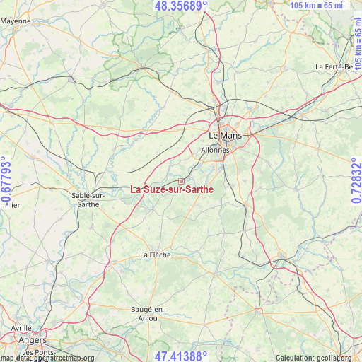
La Suze-sur-Sarthe GPS coordinates[2]
47° 53' 15.108" North, 0° 1' 30.684" East
| Map corner | latitude | longitude |
|---|---|---|
| Upper-left | 48.35689°, | -0.67793° |
| Center: | 47.88753°, | 0.02519° |
| Lower-right: | 47.41388°, | 0.72832° |
| Map W x H: | 104.9×104.9 km | = 65.2×65.2mi |
| max Lat: | 51.07786° ⇑42.7% North |
| La Suze-sur-Sarthe: | 47.88753° |
| min Lat: | ⇓57.3% South 41.3874° |
| min Long | La Suze-sur-Sar | max Long |
| -5.08615° | 0.02519° | 9.52242° |
| W 22.1%⇐ | ⇒77.9% E |
Elevation
Elevation of La Suze-sur-Sarthe is 47 m = 154 ft, and this is 146.7 m = 481 ft below average elevation for this country.
| Max E: |
2333 m = 7654 ft | 83.1% |
| Avg. | 193.7 m = 635 ft | |
| La Suze-sur-Sarthe | 47 m = 154 ft | |
Min E: |
-1 m = -3 ft | 16.9% |
See also: France elevation on elevation.city.
Geographical zone
La Suze-sur-Sarthe is located in North temperate zone (between Tropic of Cancer and the Arctic Circle). Distance of this North polar circle is 2076.6 km =1290.3 mi to North.| Distance of | km | miles | from La Suze-sur-Sarthe |
|---|---|---|---|
| North Pole | 4682.5 | 2909.6 | to North |
| Arctic Circle | 2076.6 | 1290.3 | to North |
| Tropic Cancer | 2718.7 | 1689.3 | to South |
| Equator | 5324.6 | 3308.6 | to South |


Nearby cities:
15 places around La Suze-sur-Sarthe: (largest is in red/bold)
• Chemiré-le-Gaudin
5.5 km =3.4 mi,  326°
326°
• Cérans-Foulletourte
7.8 km =4.8 mi,  150°
150°
• Fercé-sur-Sarthe
4.5 km =2.8 mi,  290°
290°
• Fillé
7.6 km =4.7 mi,  79°
79°
• Guécélard
7.8 km =4.8 mi,  98°
98°
• Louplande
8.9 km =5.5 mi,  321°
321°
• Mézeray
7.5 km =4.7 mi,  205°
205°
• Noyen-sur-Sarthe
9.4 km =5.8 mi,  259°
259°
• Parigné-le-Pôlin
7.4 km =4.6 mi,  124°
124°
• Roézé-sur-Sarthe
3.3 km =2.1 mi,  74°
74°
• Saint-Jean-du-Bois
5.1 km =3.2 mi,  249°
249°
• Souligné-Flacé
9.7 km =6 mi,  354°
354°
• Spay
10.3 km =6.4 mi, 66°
• Voivres-lès-le-Mans
5.8 km =3.6 mi,  36°
36°
• Étival-lès-le-Mans
8.2 km =5.1 mi,  31°
31°
Sources, notices
• [Note1] Compared only with cities in France existing in our database
• [Src1] Map data: © OpenStreetMap contributors (CC-BY-SA)
• [Src2] Other city data from geonames.org with taken over terms of usage.
• [Src3] Geographical zone / Annual Mean Temperature by Robert A. Rohde @ Wikipedia
