Maché geodata
Maché (Pays de la Loire) is a populated place; located in France in Europe/Paris (GMT+2) time zone. With population of 1,165 people, there are 7732 cities with bigger population in this country. Compared to other cities in France, 57.7% of cities are located further ↑North; 93.4% of cities are located further →East and 84.9% of cities have higher elevation than Maché. Note1
Administrative division(s):
- Level 1: Pays de la Loire
- Level 2: Département de la Vendée
- Level 3: Arrondissement de La Roche-sur-Yon
- Level 4: Maché


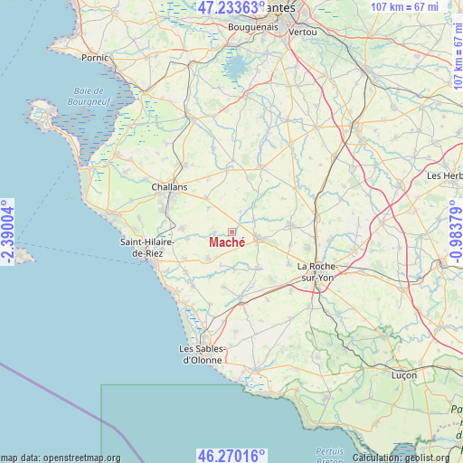
Maché GPS coordinates[2]
46° 45' 14.58" North, 1° 41' 12.912" West
| Map corner | latitude | longitude |
|---|---|---|
| Upper-left | 47.23363°, | -2.39004° |
| Center: | 46.75405°, | -1.68692° |
| Lower-right: | 46.27016°, | -0.98379° |
| Map W x H: | 107.1×107.1 km | = 66.5×66.5mi |
| max Lat: | 51.07786° ⇑57.7% North |
| Maché: | 46.75405° |
| min Lat: | ⇓42.3% South 41.3874° |
| min Long | Maché | max Long |
| -5.08615° | -1.68692° | 9.52242° |
| W 6.6%⇐ | ⇒93.4% E |
Elevation
Elevation of Maché is 42 m = 138 ft, and this is 151.7 m = 498 ft below average elevation for this country.
| Max E: |
2333 m = 7654 ft | 84.9% |
| Avg. | 193.7 m = 635 ft | |
| Maché | 42 m = 138 ft | |
Min E: |
-1 m = -3 ft | 15.1% |
See also: France elevation on elevation.city.
Geographical zone
Maché is located in North temperate zone (between Tropic of Cancer and the Arctic Circle). Distance of this North polar circle is 2202.6 km =1368.6 mi to North.| Distance of | km | miles | from Maché |
|---|---|---|---|
| North Pole | 4808.5 | 2987.9 | to North |
| Arctic Circle | 2202.6 | 1368.6 | to North |
| Tropic Cancer | 2592.6 | 1611 | to South |
| Equator | 5198.6 | 3230.3 | to South |


Nearby cities:
15 places around Maché: (largest is in red/bold)
• Aizenay
6.2 km =3.9 mi,  104°
104°
• Apremont
4.1 km =2.5 mi,  261°
261°
• Beaulieu-sous-la-Roche
10.4 km =6.5 mi,  146°
146°
• Commequiers
11.6 km =7.2 mi,  273°
273°
• Coëx
8.3 km =5.2 mi,  221°
221°
• La Chapelle-Hermier
8.4 km =5.2 mi,  198°
198°
• La Chapelle-Palluau
5.9 km =3.7 mi,  57°
57°
• Martinet
8.7 km =5.4 mi,  177°
177°
• Palluau
7.6 km =4.7 mi,  42°
42°
• Saint-Christophe-du-Ligneron
9.9 km =6.2 mi,  322°
322°
• Saint-Julien-des-Landes
12.9 km =8 mi,  189°
189°
• Saint-Maixent-sur-Vie
10.5 km =6.5 mi, 261°
• Saint-Paul-Mont-Penit
5.1 km =3.2 mi,  21°
21°
• Saint-Révérend
12.6 km =7.8 mi,  240°
240°
• Saint-Étienne-du-Bois
10.9 km =6.8 mi, 38°
Sources, notices
• [Note1] Compared only with cities in France existing in our database
• [Src1] Map data: © OpenStreetMap contributors (CC-BY-SA)
• [Src2] Other city data from geonames.org with taken over terms of usage.
• [Src3] Geographical zone / Annual Mean Temperature by Robert A. Rohde @ Wikipedia
