Lynde geodata
Lynde (Hauts-de-France) is a populated place; located in France in Europe/Paris (GMT+2) time zone. With population of 627 people, there are 12867 cities with bigger population in this country. Compared to other cities in France, 98.9% of cities are located further ↓South; 50.7% of cities are located further →East and 79% of cities have higher elevation than Lynde. Note1
Administrative division(s):
- Level 1: Hauts-de-France
- Level 2: Nord
- Level 3: Arrondissement de Dunkerque
- Level 4: Lynde


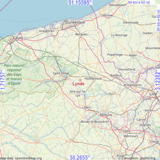
Lynde GPS coordinates[2]
50° 42' 46.224" North, 2° 25' 14.52" East
| Map corner | latitude | longitude |
|---|---|---|
| Upper-left | 51.15595°, | 1.71757° |
| Center: | 50.71284°, | 2.4207° |
| Lower-right: | 50.2655°, | 3.12382° |
| Map W x H: | 99×99 km | = 61.5×61.5mi |
| max Lat: | 51.07786° ⇑1.1% North |
| Lynde: | 50.71284° |
| min Lat: | ⇓98.9% South 41.3874° |
| min Long | Lynde | max Long |
| -5.08615° | 2.4207° | 9.52242° |
| W 49.3%⇐ | ⇒50.7% E |
Elevation
Elevation of Lynde is 57 m = 187 ft, and this is 136.7 m = 448 ft below average elevation for this country.
| Max E: |
2333 m = 7654 ft | 79% |
| Avg. | 193.7 m = 635 ft | |
| Lynde | 57 m = 187 ft | |
Min E: |
-1 m = -3 ft | 21% |
See also: France elevation on elevation.city.
Geographical zone
Lynde is located in North temperate zone (between Tropic of Cancer and the Arctic Circle). Distance of this North polar circle is 1762.4 km =1095.1 mi to North.| Distance of | km | miles | from Lynde |
|---|---|---|---|
| North Pole | 4368.3 | 2714.3 | to North |
| Arctic Circle | 1762.4 | 1095.1 | to North |
| Tropic Cancer | 3032.8 | 1884.5 | to South |
| Equator | 5638.7 | 3503.7 | to South |


Nearby cities:
15 places around Lynde: (largest is in red/bold)
• Blaringhem
2.7 km =1.7 mi,  207°
207°
• Campagne-lès-Wardrecques
6.2 km =3.9 mi,  276°
276°
• Ebblinghem
2.3 km =1.4 mi,  340°
340°
• Hazebrouck
8.3 km =5.2 mi,  81°
81°
• Morbecque
7.2 km =4.5 mi,  107°
107°
• Quiestède
7.1 km =4.4 mi,  240°
240°
• Racquinghem
5 km =3.1 mi, 243°
• Renescure
4.1 km =2.5 mi,  293°
293°
• Roquetoire
7.2 km =4.5 mi,  229°
229°
• Staple
4.7 km =2.9 mi,  30°
30°
• Steenbecque
6.2 km =3.9 mi,  133°
133°
• Thiennes
7.6 km =4.7 mi,  154°
154°
• Wallon-Cappel
4.1 km =2.5 mi,  67°
67°
• Wardrecques
5.3 km =3.3 mi,  267°
267°
• Wittes
5.2 km =3.2 mi,  203°
203°
Sources, notices
• [Note1] Compared only with cities in France existing in our database
• [Src1] Map data: © OpenStreetMap contributors (CC-BY-SA)
• [Src2] Other city data from geonames.org with taken over terms of usage.
• [Src3] Geographical zone / Annual Mean Temperature by Robert A. Rohde @ Wikipedia
