Quiestède geodata
Quiestède (Hauts-de-France) is a populated place; located in France in Europe/Paris (GMT+2) time zone. With population of 654 people, there are 12467 cities with bigger population in this country. Compared to other cities in France, 98.7% of cities are located further ↓South; 52.1% of cities are located further →East and 90.3% of cities have higher elevation than Quiestède. Note1
Administrative division(s):
- Level 1: Hauts-de-France
- Level 2: Pas-de-Calais
- Level 3: Arrondissement de Saint-Omer
- Level 4: Quiestède


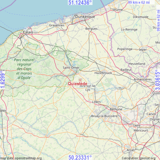
Quiestède GPS coordinates[2]
50° 40' 51.42" North, 2° 19' 58.872" East
| Map corner | latitude | longitude |
|---|---|---|
| Upper-left | 51.12436°, | 1.6299° |
| Center: | 50.68095°, | 2.33302° |
| Lower-right: | 50.23331°, | 3.03615° |
| Map W x H: | 99.1×99.1 km | = 61.6×61.6mi |
| max Lat: | 51.07786° ⇑1.3% North |
| Quiestède: | 50.68095° |
| min Lat: | ⇓98.7% South 41.3874° |
| min Long | Quiestède | max Long |
| -5.08615° | 2.33302° | 9.52242° |
| W 47.9%⇐ | ⇒52.1% E |
Elevation
Elevation of Quiestède is 29 m = 95 ft, and this is 164.7 m = 540 ft below average elevation for this country.
| Max E: |
2333 m = 7654 ft | 90.3% |
| Avg. | 193.7 m = 635 ft | |
| Quiestède | 29 m = 95 ft | |
Min E: |
-1 m = -3 ft | 9.7% |
See also: France elevation on elevation.city.
Geographical zone
Quiestède is located in North temperate zone (between Tropic of Cancer and the Arctic Circle). Distance of this North polar circle is 1766 km =1097.3 mi to North.| Distance of | km | miles | from Quiestède |
|---|---|---|---|
| North Pole | 4371.9 | 2716.6 | to North |
| Arctic Circle | 1766 | 1097.3 | to North |
| Tropic Cancer | 3029.3 | 1882.3 | to South |
| Equator | 5635.2 | 3501.5 | to South |


Nearby cities:
15 places around Quiestède: (largest is in red/bold)
• Aire-sur-la-Lys
6.6 km =4.1 mi,  135°
135°
• Arques
6.3 km =3.9 mi,  339°
339°
• Blaringhem
5.1 km =3.2 mi,  77°
77°
• Blendecques
5.3 km =3.3 mi,  321°
321°
• Campagne-lès-Wardrecques
4.2 km =2.6 mi,  0°
0°
• Ecques
3.5 km =2.2 mi,  249°
249°
• Helfaut
6.7 km =4.2 mi,  286°
286°
• Heuringhem
3.9 km =2.4 mi,  296°
296°
• Lynde
7.1 km =4.4 mi,  60°
60°
• Mametz
5.2 km =3.2 mi,  186°
186°
• Racquinghem
2.1 km =1.3 mi,  53°
53°
• Renescure
5.7 km =3.5 mi,  25°
25°
• Roquetoire
1.4 km =0.9 mi,  149°
149°
• Wardrecques
3.5 km =2.2 mi,  13°
13°
• Wittes
4.3 km =2.7 mi,  106°
106°
Sources, notices
• [Note1] Compared only with cities in France existing in our database
• [Src1] Map data: © OpenStreetMap contributors (CC-BY-SA)
• [Src2] Other city data from geonames.org with taken over terms of usage.
• [Src3] Geographical zone / Annual Mean Temperature by Robert A. Rohde @ Wikipedia
