Steenbecque geodata
Steenbecque (Hauts-de-France) is a populated place; located in France in Europe/Paris (GMT+2) time zone. With population of 1,674 people, there are 5592 cities with bigger population in this country. Compared to other cities in France, 98.6% of cities are located further ↓South; 50.3% of cities are located further ←West and 92% of cities have higher elevation than Steenbecque. Note1
Administrative division(s):
- Level 1: Hauts-de-France
- Level 2: Nord
- Level 3: Arrondissement de Dunkerque
- Level 4: Steenbecque


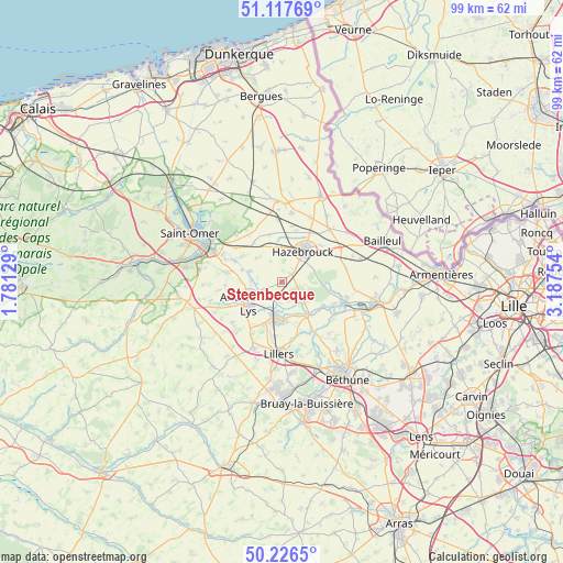
Steenbecque GPS coordinates[2]
50° 40' 27.156" North, 2° 29' 3.912" East
| Map corner | latitude | longitude |
|---|---|---|
| Upper-left | 51.11769°, | 1.78129° |
| Center: | 50.67421°, | 2.48442° |
| Lower-right: | 50.2265°, | 3.18754° |
| Map W x H: | 99.1×99.1 km | = 61.6×61.6mi |
| max Lat: | 51.07786° ⇑1.4% North |
| Steenbecque: | 50.67421° |
| min Lat: | ⇓98.6% South 41.3874° |
| min Long | Steenbecque | max Long |
| -5.08615° | 2.48442° | 9.52242° |
| W 50.3%⇐ | ⇒49.7% E |
Elevation
Elevation of Steenbecque is 25 m = 82 ft, and this is 168.7 m = 553 ft below average elevation for this country.
| Max E: |
2333 m = 7654 ft | 92% |
| Avg. | 193.7 m = 635 ft | |
| Steenbecque | 25 m = 82 ft | |
Min E: |
-1 m = -3 ft | 8% |
See also: France elevation on elevation.city.
Geographical zone
Steenbecque is located in North temperate zone (between Tropic of Cancer and the Arctic Circle). Distance of this North polar circle is 1766.7 km =1097.8 mi to North.| Distance of | km | miles | from Steenbecque |
|---|---|---|---|
| North Pole | 4372.6 | 2717 | to North |
| Arctic Circle | 1766.7 | 1097.8 | to North |
| Tropic Cancer | 3028.5 | 1881.8 | to South |
| Equator | 5634.4 | 3501.1 | to South |


Nearby cities:
15 places around Steenbecque: (largest is in red/bold)
• Aire-sur-la-Lys
7.2 km =4.5 mi,  236°
236°
• Blaringhem
6 km =3.7 mi,  288°
288°
• Ebblinghem
8.3 km =5.2 mi,  320°
320°
• Guarbecque
7 km =4.3 mi,  177°
177°
• Haverskerque
5.5 km =3.4 mi,  132°
132°
• Hazebrouck
6.6 km =4.1 mi,  34°
34°
• Isbergues
5.9 km =3.7 mi,  197°
197°
• Lambres
8.8 km =5.5 mi,  224°
224°
• Lynde
6.2 km =3.9 mi,  313°
313°
• Morbecque
3.2 km =2 mi,  47°
47°
• Saint-Venant
7.2 km =4.5 mi,  147°
147°
• Staple
8.6 km =5.3 mi,  345°
345°
• Thiennes
2.8 km =1.7 mi,  206°
206°
• Wallon-Cappel
5.9 km =3.7 mi, 352°
• Wittes
6.6 km =4.1 mi,  265°
265°
Sources, notices
• [Note1] Compared only with cities in France existing in our database
• [Src1] Map data: © OpenStreetMap contributors (CC-BY-SA)
• [Src2] Other city data from geonames.org with taken over terms of usage.
• [Src3] Geographical zone / Annual Mean Temperature by Robert A. Rohde @ Wikipedia
