Racquinghem geodata
Racquinghem (Hauts-de-France) is a populated place; located in France in Europe/Paris (GMT+2) time zone. With population of 2,140 people, there are 4486 cities with bigger population in this country. Compared to other cities in France, 98.8% of cities are located further ↓South; 51.7% of cities are located further →East and 84.9% of cities have higher elevation than Racquinghem. Note1
Administrative division(s):
- Level 1: Hauts-de-France
- Level 2: Pas-de-Calais
- Level 3: Arrondissement de Saint-Omer
- Level 4: Racquinghem


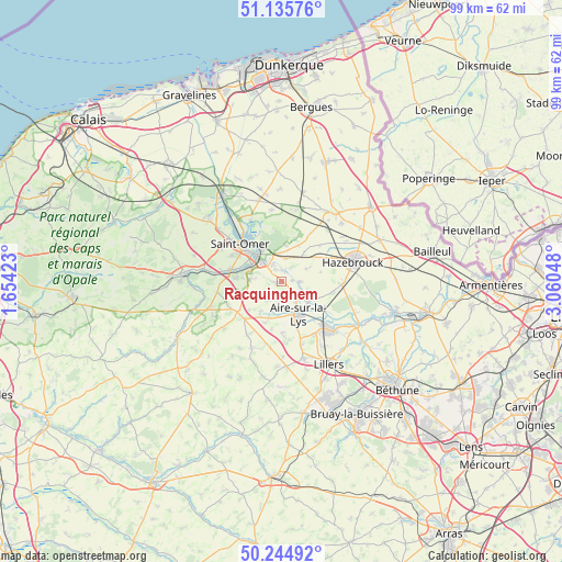
Racquinghem GPS coordinates[2]
50° 41' 32.82" North, 2° 21' 26.496" East
| Map corner | latitude | longitude |
|---|---|---|
| Upper-left | 51.13576°, | 1.65423° |
| Center: | 50.69245°, | 2.35736° |
| Lower-right: | 50.24492°, | 3.06048° |
| Map W x H: | 99.1×99.1 km | = 61.6×61.6mi |
| max Lat: | 51.07786° ⇑1.2% North |
| Racquinghem: | 50.69245° |
| min Lat: | ⇓98.8% South 41.3874° |
| min Long | Racquinghem | max Long |
| -5.08615° | 2.35736° | 9.52242° |
| W 48.3%⇐ | ⇒51.7% E |
Elevation
Elevation of Racquinghem is 42 m = 138 ft, and this is 151.7 m = 498 ft below average elevation for this country.
| Max E: |
2333 m = 7654 ft | 84.9% |
| Avg. | 193.7 m = 635 ft | |
| Racquinghem | 42 m = 138 ft | |
Min E: |
-1 m = -3 ft | 15.1% |
See also: France elevation on elevation.city.
Geographical zone
Racquinghem is located in North temperate zone (between Tropic of Cancer and the Arctic Circle). Distance of this North polar circle is 1764.7 km =1096.5 mi to North.| Distance of | km | miles | from Racquinghem |
|---|---|---|---|
| North Pole | 4370.6 | 2715.8 | to North |
| Arctic Circle | 1764.7 | 1096.5 | to North |
| Tropic Cancer | 3030.6 | 1883.1 | to South |
| Equator | 5636.5 | 3502.4 | to South |


Nearby cities:
15 places around Racquinghem: (largest is in red/bold)
• Aire-sur-la-Lys
6.6 km =4.1 mi,  153°
153°
• Arques
6 km =3.7 mi,  319°
319°
• Blaringhem
3.2 km =2 mi,  92°
92°
• Blendecques
5.8 km =3.6 mi,  299°
299°
• Campagne-lès-Wardrecques
3.4 km =2.1 mi,  330°
330°
• Ebblinghem
5.8 km =3.6 mi,  39°
39°
• Ecques
5.6 km =3.5 mi,  243°
243°
• Heuringhem
5.2 km =3.2 mi,  274°
274°
• Lynde
5 km =3.1 mi,  63°
63°
• Mametz
6.8 km =4.2 mi,  199°
199°
• Quiestède
2.1 km =1.3 mi,  233°
233°
• Renescure
4 km =2.5 mi,  10°
10°
• Roquetoire
2.7 km =1.7 mi, 202°
• Wardrecques
2.3 km =1.4 mi,  336°
336°
• Wittes
3.5 km =2.2 mi,  136°
136°
Sources, notices
• [Note1] Compared only with cities in France existing in our database
• [Src1] Map data: © OpenStreetMap contributors (CC-BY-SA)
• [Src2] Other city data from geonames.org with taken over terms of usage.
• [Src3] Geographical zone / Annual Mean Temperature by Robert A. Rohde @ Wikipedia
