Luzillé geodata
Luzillé (Centre) is a populated place; located in France in Europe/Paris (GMT+2) time zone. With population of 797 people, there are 10649 cities with bigger population in this country. Compared to other cities in France, 52.1% of cities are located further ↑North; 68.2% of cities are located further →East and 64% of cities have higher elevation than Luzillé. Note1
Administrative division(s):
- Level 1: Centre
- Level 2: Département d'Indre-et-Loire
- Level 3: Arrondissement de Loches
- Level 4: Luzillé


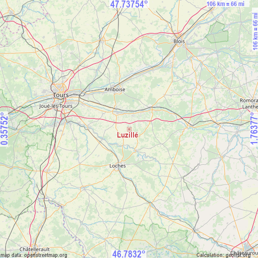
Luzillé GPS coordinates[2]
47° 15' 45.072" North, 1° 3' 38.304" East
| Map corner | latitude | longitude |
|---|---|---|
| Upper-left | 47.73754°, | 0.35752° |
| Center: | 47.26252°, | 1.06064° |
| Lower-right: | 46.7832°, | 1.76377° |
| Map W x H: | 106.1×106.1 km | = 65.9×65.9mi |
| max Lat: | 51.07786° ⇑52.1% North |
| Luzillé: | 47.26252° |
| min Lat: | ⇓47.9% South 41.3874° |
| min Long | Luzillé | max Long |
| -5.08615° | 1.06064° | 9.52242° |
| W 31.8%⇐ | ⇒68.2% E |
Elevation
Elevation of Luzillé is 92 m = 302 ft, and this is 101.7 m = 334 ft below average elevation for this country.
| Max E: |
2333 m = 7654 ft | 64% |
| Avg. | 193.7 m = 635 ft | |
| Luzillé | 92 m = 302 ft | |
Min E: |
-1 m = -3 ft | 36% |
See also: France elevation on elevation.city.
Geographical zone
Luzillé is located in North temperate zone (between Tropic of Cancer and the Arctic Circle). Distance of this North polar circle is 2146.1 km =1333.5 mi to North.| Distance of | km | miles | from Luzillé |
|---|---|---|---|
| North Pole | 4752 | 2952.8 | to North |
| Arctic Circle | 2146.1 | 1333.5 | to North |
| Tropic Cancer | 2649.2 | 1646.1 | to South |
| Equator | 5255.1 | 3265.4 | to South |


Nearby cities:
15 places around Luzillé: (largest is in red/bold)
• Athée-sur-Cher
12.6 km =7.8 mi,  300°
300°
• Bléré
8.9 km =5.5 mi,  324°
324°
• Chambourg-sur-Indre
11.4 km =7.1 mi,  217°
217°
• Chissay-en-Touraine
10 km =6.2 mi,  33°
33°
• Chisseaux
8 km =5 mi,  17°
17°
• Civray-de-Touraine
7.8 km =4.8 mi,  353°
353°
• Dierre
12 km =7.5 mi, 319°
• Faverolles-sur-Cher
11.5 km =7.1 mi,  58°
58°
• Francueil
5.9 km =3.7 mi, 17°
• Genillé
9.3 km =5.8 mi,  161°
161°
• La Croix-en-Touraine
10.1 km =6.3 mi,  328°
328°
• Montrichard
13.1 km =8.1 mi,  46°
46°
• Reignac-sur-Indre
11.6 km =7.2 mi,  249°
249°
• Saint-Georges-sur-Cher
9.3 km =5.8 mi,  35°
35°
• Saint-Julien-de-Chédon
11.7 km =7.3 mi,  67°
67°
Sources, notices
• [Note1] Compared only with cities in France existing in our database
• [Src1] Map data: © OpenStreetMap contributors (CC-BY-SA)
• [Src2] Other city data from geonames.org with taken over terms of usage.
• [Src3] Geographical zone / Annual Mean Temperature by Robert A. Rohde @ Wikipedia
