La Croix-en-Touraine geodata
La Croix-en-Touraine (Centre) is a populated place; located in France in Europe/Paris (GMT+2) time zone. With population of 2,094 people, there are 4599 cities with bigger population in this country. Compared to other cities in France, 50.9% of cities are located further ↑North; 68.9% of cities are located further →East and 77.8% of cities have higher elevation than La Croix-en-Touraine. Note1
Administrative division(s):
- Level 1: Centre
- Level 2: Département d'Indre-et-Loire
- Level 3: Arrondissement de Loches
- Level 4: La Croix-en-Touraine


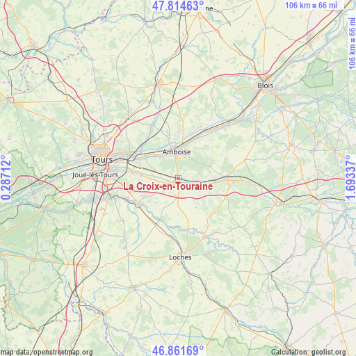
La Croix-en-Touraine GPS coordinates[2]
47° 20' 25.116" North, 0° 59' 24.864" East
| Map corner | latitude | longitude |
|---|---|---|
| Upper-left | 47.81463°, | 0.28712° |
| Center: | 47.34031°, | 0.99024° |
| Lower-right: | 46.86169°, | 1.69337° |
| Map W x H: | 106×106 km | = 65.9×65.9mi |
| max Lat: | 51.07786° ⇑50.9% North |
| La Croix-en-Touraine: | 47.34031° |
| min Lat: | ⇓49.1% South 41.3874° |
| min Long | La Croix-en-Tou | max Long |
| -5.08615° | 0.99024° | 9.52242° |
| W 31.1%⇐ | ⇒68.9% E |
Elevation
Elevation of La Croix-en-Touraine is 60 m = 197 ft, and this is 133.7 m = 439 ft below average elevation for this country.
| Max E: |
2333 m = 7654 ft | 77.8% |
| Avg. | 193.7 m = 635 ft | |
| La Croix-en-Touraine | 60 m = 197 ft | |
Min E: |
-1 m = -3 ft | 22.2% |
See also: France elevation on elevation.city.
Geographical zone
La Croix-en-Touraine is located in North temperate zone (between Tropic of Cancer and the Arctic Circle). Distance of this North polar circle is 2137.4 km =1328.1 mi to North.| Distance of | km | miles | from La Croix-en-Touraine |
|---|---|---|---|
| North Pole | 4743.3 | 2947.3 | to North |
| Arctic Circle | 2137.4 | 1328.1 | to North |
| Tropic Cancer | 2657.8 | 1651.5 | to South |
| Equator | 5263.7 | 3270.7 | to South |


Nearby cities:
15 places around La Croix-en-Touraine: (largest is in red/bold)
• Amboise
8 km =5 mi,  355°
355°
• Athée-sur-Cher
6 km =3.7 mi,  248°
248°
• Azay-sur-Cher
10.9 km =6.8 mi,  275°
275°
• Bléré
1.4 km =0.9 mi,  175°
175°
• Chargé
10.7 km =6.6 mi,  16°
16°
• Chissay-en-Touraine
10.8 km =6.7 mi,  91°
91°
• Chisseaux
7.7 km =4.8 mi,  97°
97°
• Civray-de-Touraine
4.5 km =2.8 mi, 100°
• Dierre
2.5 km =1.6 mi, 282°
• Francueil
7.7 km =4.8 mi,  113°
113°
• Lussault-sur-Loire
8.2 km =5.1 mi,  317°
317°
• Luzillé
10.1 km =6.3 mi,  148°
148°
• Nazelles-Négron
10.8 km =6.7 mi,  343°
343°
• Saint-Georges-sur-Cher
10.8 km =6.7 mi, 96°
• Saint-Martin-le-Beau
6.3 km =3.9 mi,  285°
285°
Sources, notices
• [Note1] Compared only with cities in France existing in our database
• [Src1] Map data: © OpenStreetMap contributors (CC-BY-SA)
• [Src2] Other city data from geonames.org with taken over terms of usage.
• [Src3] Geographical zone / Annual Mean Temperature by Robert A. Rohde @ Wikipedia
