Genillé geodata
Genillé (Centre) is a populated place; located in France in Europe/Paris (GMT+2) time zone. With population of 1,526 people, there are 6101 cities with bigger population in this country. Compared to other cities in France, 53.2% of cities are located further ↑North; 67.8% of cities are located further →East and 65.6% of cities have higher elevation than Genillé. Note1
Administrative division(s):
- Level 1: Centre
- Level 2: Département d'Indre-et-Loire
- Level 3: Arrondissement de Loches
- Level 4: Genillé


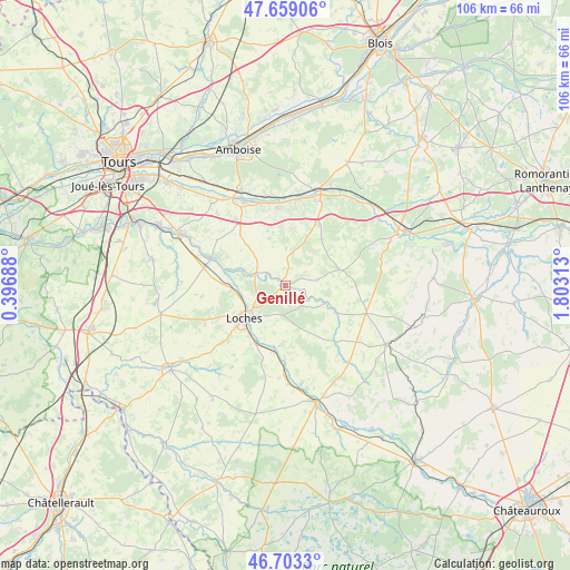
Genillé GPS coordinates[2]
47° 10' 59.988" North, 1° 6' 0" East
| Map corner | latitude | longitude |
|---|---|---|
| Upper-left | 47.65906°, | 0.39688° |
| Center: | 47.18333°, | 1.1° |
| Lower-right: | 46.7033°, | 1.80313° |
| Map W x H: | 106.3×106.3 km | = 66.1×66.1mi |
| max Lat: | 51.07786° ⇑53.2% North |
| Genillé: | 47.18333° |
| min Lat: | ⇓46.8% South 41.3874° |
| min Long | Genillé | max Long |
| -5.08615° | 1.1° | 9.52242° |
| W 32.2%⇐ | ⇒67.8% E |
Elevation
Elevation of Genillé is 88 m = 289 ft, and this is 105.7 m = 347 ft below average elevation for this country.
| Max E: |
2333 m = 7654 ft | 65.6% |
| Avg. | 193.7 m = 635 ft | |
| Genillé | 88 m = 289 ft | |
Min E: |
-1 m = -3 ft | 34.4% |
See also: France elevation on elevation.city.
Geographical zone
Genillé is located in North temperate zone (between Tropic of Cancer and the Arctic Circle). Distance of this North polar circle is 2154.9 km =1339 mi to North.| Distance of | km | miles | from Genillé |
|---|---|---|---|
| North Pole | 4760.8 | 2958.2 | to North |
| Arctic Circle | 2154.9 | 1339 | to North |
| Tropic Cancer | 2640.4 | 1640.7 | to South |
| Equator | 5246.3 | 3259.9 | to South |


Nearby cities:
15 places around Genillé: (largest is in red/bold)
• Beaulieu-lès-Loches
9.1 km =5.7 mi,  224°
224°
• Chambourg-sur-Indre
9.9 km =6.2 mi,  268°
268°
• Ferrière-sur-Beaulieu
6.9 km =4.3 mi, 222°
• Francueil
14.4 km =8.9 mi,  355°
355°
• Loches
10 km =6.2 mi,  232°
232°
• Loché-sur-Indrois
13.6 km =8.5 mi,  138°
138°
• Luzillé
9.3 km =5.8 mi,  341°
341°
• Orbigny
10.6 km =6.6 mi,  73°
73°
• Perrusson
11.4 km =7.1 mi,  214°
214°
• Reignac-sur-Indre
14.7 km =9.1 mi,  289°
289°
• Saint-Hippolyte
13.8 km =8.6 mi,  179°
179°
• Saint-Jean-Saint-Germain
12.2 km =7.6 mi,  203°
203°
• Saint-Julien-de-Chédon
15.5 km =9.6 mi,  30°
30°
• Verneuil-sur-Indre
14.9 km =9.3 mi, 197°
• Villeloin-Coulangé
10.5 km =6.5 mi,  116°
116°
Sources, notices
• [Note1] Compared only with cities in France existing in our database
• [Src1] Map data: © OpenStreetMap contributors (CC-BY-SA)
• [Src2] Other city data from geonames.org with taken over terms of usage.
• [Src3] Geographical zone / Annual Mean Temperature by Robert A. Rohde @ Wikipedia
