Lusans geodata
Lusans (Bourgogne-Franche-Comté) is a populated place; located in France in Europe/Paris (GMT+2) time zone. With population of 722 people, there are 11512 cities with bigger population in this country. Compared to other cities in France, 50.7% of cities are located further ↑North; 89.4% of cities are located further ←West and 80.4% of cities have lower elevation than Lusans. Note1
Administrative division(s):
- Level 1: Bourgogne-Franche-Comté
- Level 2: Doubs
- Level 3: Arrondissement de Besançon
- Level 4: Pouligney-Lusans


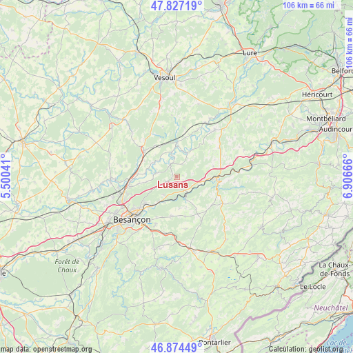
Lusans GPS coordinates[2]
47° 21' 10.764" North, 6° 12' 12.708" East
| Map corner | latitude | longitude |
|---|---|---|
| Upper-left | 47.82719°, | 5.50041° |
| Center: | 47.35299°, | 6.20353° |
| Lower-right: | 46.87449°, | 6.90666° |
| Map W x H: | 105.9×105.9 km | = 65.8×65.8mi |
| max Lat: | 51.07786° ⇑50.7% North |
| Lusans: | 47.35299° |
| min Lat: | ⇓49.3% South 41.3874° |
| min Long | Lusans | max Long |
| -5.08615° | 6.20353° | 9.52242° |
| W 89.4%⇐ | ⇒10.6% E |
Elevation
Elevation of Lusans is 295 m = 968 ft, and this is 101.3 m = 332 ft above average elevation for this country.
| Max E: |
2333 m = 7654 ft | 19.6% |
| Lusans | 295 m 968 ft | |
| Avg. | 193.7 m = 635 ft | |
Min E: |
-1 m = -3 ft | 80.4% |
See also: France elevation on elevation.city.
Geographical zone
Lusans is located in North temperate zone (between Tropic of Cancer and the Arctic Circle). Distance of this North polar circle is 2136 km =1327.2 mi to North.| Distance of | km | miles | from Lusans |
|---|---|---|---|
| North Pole | 4741.9 | 2946.5 | to North |
| Arctic Circle | 2136 | 1327.2 | to North |
| Tropic Cancer | 2659.2 | 1652.3 | to South |
| Equator | 5265.2 | 3271.6 | to South |


Nearby cities:
15 places around Lusans: (largest is in red/bold)
• Amagney
6.6 km =4.1 mi,  216°
216°
• Baume-les-Dames
11.9 km =7.4 mi,  90°
90°
• Bonnay
11.8 km =7.3 mi,  259°
259°
• Bouclans
12.2 km =7.6 mi,  167°
167°
• Chalezeule
14.3 km =8.9 mi, 222°
• Deluz
6.6 km =4.1 mi,  181°
181°
• Gennes
13.2 km =8.2 mi,  209°
209°
• Marchaux
6.5 km =4 mi,  236°
236°
• Nancray
12.1 km =7.5 mi,  187°
187°
• Novillars
9.5 km =5.9 mi, 216°
• Rioz
13.1 km =8.1 mi,  307°
307°
• Roche-lez-Beaupré
10.1 km =6.3 mi, 220°
• Roulans
4.6 km =2.9 mi,  155°
155°
• Thise
11.9 km =7.4 mi,  230°
230°
• Vieilley
9.5 km =5.9 mi, 258°
Sources, notices
• [Note1] Compared only with cities in France existing in our database
• [Src1] Map data: © OpenStreetMap contributors (CC-BY-SA)
• [Src2] Other city data from geonames.org with taken over terms of usage.
• [Src3] Geographical zone / Annual Mean Temperature by Robert A. Rohde @ Wikipedia
