Louey geodata
Louey (Occitanie) is a populated place; located in France in Europe/Paris (GMT+2) time zone. With population of 965 people, there are 9092 cities with bigger population in this country. Compared to other cities in France, 97.4% of cities are located further ↑North; 78% of cities are located further →East and 85.5% of cities have lower elevation than Louey. Note1
Administrative division(s):
- Level 1: Occitanie
- Level 2: Département des Hautes-Pyrénées
- Level 3: Arrondissement de Tarbes
- Level 4: Louey


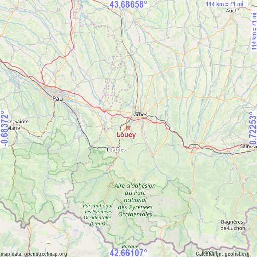
Louey GPS coordinates[2]
43° 10' 33.528" North, 0° 1' 9.84" East
| Map corner | latitude | longitude |
|---|---|---|
| Upper-left | 43.68658°, | -0.68372° |
| Center: | 43.17598°, | 0.0194° |
| Lower-right: | 42.66107°, | 0.72253° |
| Map W x H: | 114×114 km | = 70.8×70.8mi |
| max Lat: | 51.07786° ⇑97.4% North |
| Louey: | 43.17598° |
| min Lat: | ⇓2.6% South 41.3874° |
| min Long | Louey | max Long |
| -5.08615° | 0.0194° | 9.52242° |
| W 22%⇐ | ⇒78% E |
Elevation
Elevation of Louey is 353 m = 1158 ft, and this is 159.3 m = 523 ft above average elevation for this country.
| Max E: |
2333 m = 7654 ft | 14.5% |
| Louey | 353 m 1158 ft | |
| Avg. | 193.7 m = 635 ft | |
Min E: |
-1 m = -3 ft | 85.5% |
See also: France elevation on elevation.city.
Geographical zone
Louey is located in North temperate zone (between Tropic of Cancer and the Arctic Circle). Distance of this Northern Tropic circle is 2194.8 km =1363.8 mi to South.| Distance of | km | miles | from Louey |
|---|---|---|---|
| North Pole | 5206.3 | 3235 | to North |
| Arctic Circle | 2600.5 | 1615.9 | to North |
| Tropic Cancer | 2194.8 | 1363.8 | to South |
| Equator | 4800.7 | 2983 | to South |


Nearby cities:
15 places around Louey: (largest is in red/bold)
• Adé
6.4 km =4 mi,  222°
222°
• Azereix
5.4 km =3.4 mi,  327°
327°
• Barbazan-Debat
8.5 km =5.3 mi,  74°
74°
• Bernac-Debat
7.2 km =4.5 mi,  97°
97°
• Bénac
2.6 km =1.6 mi,  169°
169°
• Horgues
5.7 km =3.5 mi,  75°
75°
• Ibos
6.6 km =4.1 mi,  346°
346°
• Juillan
2.7 km =1.7 mi,  11°
11°
• Laloubère
5.4 km =3.4 mi,  54°
54°
• Lanne
1.4 km =0.9 mi,  203°
203°
• Momères
5.7 km =3.5 mi,  87°
87°
• Odos
3.8 km =2.4 mi, 53°
• Ossun
4.4 km =2.7 mi,  280°
280°
• Soues
7.3 km =4.5 mi,  61°
61°
• Tarbes
8.2 km =5.1 mi,  39°
39°
Sources, notices
• [Note1] Compared only with cities in France existing in our database
• [Src1] Map data: © OpenStreetMap contributors (CC-BY-SA)
• [Src2] Other city data from geonames.org with taken over terms of usage.
• [Src3] Geographical zone / Annual Mean Temperature by Robert A. Rohde @ Wikipedia
