Lorient geodata
Lorient (Brittany) is a seat of a third-order administrative division; located in France in Europe/Paris (GMT+2) time zone. With population of 58,112 people, there are 87 cities with bigger population in this country. Compared to other cities in France, 55% of cities are located further ↓South; 98% of cities are located further →East and 99.3% of cities have higher elevation than Lorient. Note1
Administrative division(s):
- Level 1: Brittany
- Level 2: Morbihan
- Level 3: Arrondissement de Lorient
- Level 4: Lorient


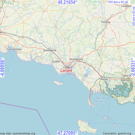
Lorient GPS coordinates[2]
47° 44' 45.204" North, 3° 21' 59.148" West
| Map corner | latitude | longitude |
|---|---|---|
| Upper-left | 48.21654°, | -4.06956° |
| Center: | 47.74589°, | -3.36643° |
| Lower-right: | 47.27095°, | -2.66331° |
| Map W x H: | 105.1×105.1 km | = 65.3×65.3mi |
| max Lat: | 51.07786° ⇑45% North |
| Lorient: | 47.74589° |
| min Lat: | ⇓55% South 41.3874° |
| min Long | Lorient | max Long |
| -5.08615° | -3.36643° | 9.52242° |
| W 2%⇐ | ⇒98% E |
Elevation
Elevation of Lorient is 5 m = 16 ft, and this is 188.7 m = 619 ft below average elevation for this country.
| Max E: |
2333 m = 7654 ft | 99.3% |
| Avg. | 193.7 m = 635 ft | |
| Lorient | 5 m = 16 ft | |
Min E: |
-1 m = -3 ft | 0.7% |
See also: Lorient elevation on elevation.city.
Geographical zone
Lorient is located in North temperate zone (between Tropic of Cancer and the Arctic Circle). Distance of this North polar circle is 2092.3 km =1300.1 mi to North.| Distance of | km | miles | from Lorient |
|---|---|---|---|
| North Pole | 4698.2 | 2919.3 | to North |
| Arctic Circle | 2092.3 | 1300.1 | to North |
| Tropic Cancer | 2702.9 | 1679.5 | to South |
| Equator | 5308.8 | 3298.7 | to South |


Nearby cities:
15 places around Lorient: (largest is in red/bold)
• Caudan
7.2 km =4.5 mi,  14°
14°
• Gestel
8.6 km =5.3 mi,  318°
318°
• Guidel-Plage
11.9 km =7.4 mi,  281°
281°
• Gâvres
5.9 km =3.7 mi,  169°
169°
• Hennebont
9.6 km =6 mi,  46°
46°
• Kervignac
9.8 km =6.1 mi,  78°
78°
• Lanester
2.6 km =1.6 mi, 49°
• Larmor-Plage
4.6 km =2.9 mi,  196°
196°
• Locmiquélic
3 km =1.9 mi,  141°
141°
• Merlevenez
10.2 km =6.3 mi,  96°
96°
• Ploemeur
5.2 km =3.2 mi,  254°
254°
• Pont-Scorff
10.1 km =6.3 mi,  344°
344°
• Port-Louis
4.4 km =2.7 mi, 168°
• Quéven
5.6 km =3.5 mi, 317°
• Riantec
5.4 km =3.4 mi, 136°
Sources, notices
• [Note1] Compared only with cities in France existing in our database
• [Src1] Map data: © OpenStreetMap contributors (CC-BY-SA)
• [Src2] Other city data from geonames.org with taken over terms of usage.
• [Src3] Geographical zone / Annual Mean Temperature by Robert A. Rohde @ Wikipedia
