Kervignac geodata
Kervignac (Brittany) is a populated place; located in France in Europe/Paris (GMT+2) time zone. With population of 4,477 people, there are 2203 cities with bigger population in this country. Compared to other cities in France, 55.2% of cities are located further ↓South; 97.8% of cities are located further →East and 87.4% of cities have higher elevation than Kervignac. Note1
Administrative division(s):
- Level 1: Brittany
- Level 2: Morbihan
- Level 3: Arrondissement de Lorient
- Level 4: Kervignac


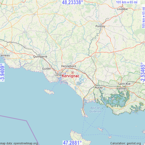
Kervignac GPS coordinates[2]
47° 45' 46.404" North, 3° 14' 16.008" West
| Map corner | latitude | longitude |
|---|---|---|
| Upper-left | 48.23338°, | -3.9409° |
| Center: | 47.76289°, | -3.23778° |
| Lower-right: | 47.2881°, | -2.53465° |
| Map W x H: | 105.1×105.1 km | = 65.3×65.3mi |
| max Lat: | 51.07786° ⇑44.8% North |
| Kervignac: | 47.76289° |
| min Lat: | ⇓55.2% South 41.3874° |
| min Long | Kervignac | max Long |
| -5.08615° | -3.23778° | 9.52242° |
| W 2.2%⇐ | ⇒97.8% E |
Elevation
Elevation of Kervignac is 36 m = 118 ft, and this is 157.7 m = 517 ft below average elevation for this country.
| Max E: |
2333 m = 7654 ft | 87.4% |
| Avg. | 193.7 m = 635 ft | |
| Kervignac | 36 m = 118 ft | |
Min E: |
-1 m = -3 ft | 12.6% |
See also: France elevation on elevation.city.
Geographical zone
Kervignac is located in North temperate zone (between Tropic of Cancer and the Arctic Circle). Distance of this North polar circle is 2090.4 km =1298.9 mi to North.| Distance of | km | miles | from Kervignac |
|---|---|---|---|
| North Pole | 4696.3 | 2918.1 | to North |
| Arctic Circle | 2090.4 | 1298.9 | to North |
| Tropic Cancer | 2704.8 | 1680.7 | to South |
| Equator | 5310.7 | 3299.9 | to South |


Nearby cities:
15 places around Kervignac: (largest is in red/bold)
• Belz
11.1 km =6.9 mi,  151°
151°
• Brandérion
4.7 km =2.9 mi,  42°
42°
• Caudan
9.3 km =5.8 mi,  303°
303°
• Gâvres
11.5 km =7.1 mi,  228°
228°
• Hennebont
5.4 km =3.4 mi,  330°
330°
• Landévant
8.6 km =5.3 mi,  88°
88°
• Lanester
7.6 km =4.7 mi,  268°
268°
• Languidic
9.8 km =6.1 mi, 37°
• Locmiquélic
8.8 km =5.5 mi,  241°
241°
• Lorient
9.8 km =6.1 mi,  258°
258°
• Merlevenez
3.1 km =1.9 mi,  169°
169°
• Nostang
4.2 km =2.6 mi,  112°
112°
• Port-Louis
10.7 km =6.6 mi, 234°
• Riantec
8.2 km =5.1 mi, 225°
• Sainte-Hélène
5.4 km =3.4 mi, 151°
Sources, notices
• [Note1] Compared only with cities in France existing in our database
• [Src1] Map data: © OpenStreetMap contributors (CC-BY-SA)
• [Src2] Other city data from geonames.org with taken over terms of usage.
• [Src3] Geographical zone / Annual Mean Temperature by Robert A. Rohde @ Wikipedia
