La Chapelle-Saint-Sauveur geodata
La Chapelle-Saint-Sauveur (Bourgogne-Franche-Comté) is a populated place; located in France in Europe/Paris (GMT+2) time zone. With population of 653 people, there are 12485 cities with bigger population in this country. Compared to other cities in France, 56.7% of cities are located further ↑North; 80.3% of cities are located further ←West and 67% of cities have lower elevation than La Chapelle-Saint-Sauveur. Note1
Administrative division(s):
- Level 1: Bourgogne-Franche-Comté
- Level 2: Département de Saône-et-Loire
- Level 3: Arrondissement de Louhans
- Level 4: La Chapelle-Saint-Sauveur
Current local time in La Chapelle-Saint-Sauveur:
02:02 PM, SaturdayDifference from your time zone: hours


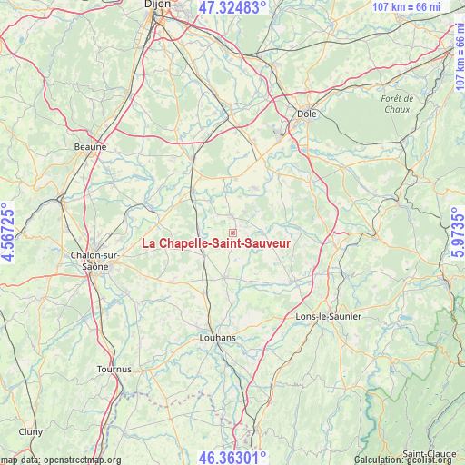
La Chapelle-Saint-Sauveur GPS coordinates[2]
46° 50' 45.852" North, 5° 16' 13.368" East
| Map corner | latitude | longitude |
|---|---|---|
| Upper-left | 47.32483°, | 4.56725° |
| Center: | 46.84607°, | 5.27038° |
| Lower-right: | 46.36301°, | 5.9735° |
| Map W x H: | 106.9×106.9 km | = 66.4×66.4mi |
| max Lat: | 51.07786° ⇑56.7% North |
| La Chapelle-Saint-Sauveur: | 46.84607° |
| min Lat: | ⇓43.3% South 41.3874° |
| min Long | La Chapelle-Sai | max Long |
| -5.08615° | 5.27038° | 9.52242° |
| W 80.3%⇐ | ⇒19.7% E |
Elevation
Elevation of La Chapelle-Saint-Sauveur is 204 m = 669 ft, and this is 10.3 m = 34 ft above average elevation for this country.
| Max E: |
2333 m = 7654 ft | 33% |
| La Chapelle-Saint-Sauveur | 204 m 669 ft | |
| Avg. | 193.7 m = 635 ft | |
Min E: |
-1 m = -3 ft | 67% |
See also: France elevation on elevation.city.
Geographical zone
La Chapelle-Saint-Sauveur is located in North temperate zone (between Tropic of Cancer and the Arctic Circle). Distance of this North polar circle is 2192.4 km =1362.3 mi to North.| Distance of | km | miles | from La Chapelle-Saint-Sauveur |
|---|---|---|---|
| North Pole | 4798.3 | 2981.5 | to North |
| Arctic Circle | 2192.4 | 1362.3 | to North |
| Tropic Cancer | 2602.9 | 1617.4 | to South |
| Equator | 5208.8 | 3236.6 | to South |


Nearby cities:
15 places around La Chapelle-Saint-Sauveur: (largest is in red/bold)
• Asnans-Beauvoisin
16 km =9.9 mi,  43°
43°
• Bletterans
17.8 km =11.1 mi,  128°
128°
• Chapelle-Voland
9.4 km =5.8 mi,  121°
121°
• Chaussin
17 km =10.6 mi, 38°
• Ciel
17.8 km =11.1 mi,  283°
283°
• Commenailles
14.7 km =9.1 mi,  109°
109°
• Frangy-en-Bresse
13.4 km =8.3 mi,  159°
159°
• Longwy-sur-le-Doubs
14.7 km =9.1 mi,  32°
32°
• Mervans
8.4 km =5.2 mi,  231°
231°
• Petit-Noir
10.8 km =6.7 mi, 26°
• Pierre-de-Bresse
4.4 km =2.7 mi,  339°
339°
• Saint-Germain-du-Bois
10.5 km =6.5 mi,  190°
190°
• Saint-Martin-en-Bresse
16.3 km =10.1 mi,  258°
258°
• Saint-Usuge
18.6 km =11.6 mi,  184°
184°
• Simard
15.6 km =9.7 mi,  205°
205°
Sources, notices
• [Note1] Compared only with cities in France existing in our database
• [Src1] Map data: © OpenStreetMap contributors (CC-BY-SA)
• [Src2] Other city data from geonames.org with taken over terms of usage.
• [Src3] Geographical zone / Annual Mean Temperature by Robert A. Rohde @ Wikipedia
