Longueville geodata
Longueville (Île-de-France) is a populated place; located in France in Europe/Paris (GMT+2) time zone. With population of 1,862 people, there are 5098 cities with bigger population in this country. Compared to other cities in France, 68.6% of cities are located further ↓South; 61.3% of cities are located further ←West and 72.6% of cities have higher elevation than Longueville. Note1
Administrative division(s):
- Level 1: Île-de-France
- Level 2: Seine-et-Marne
- Level 3: Arrondissement de Provins
- Level 4: Longueville


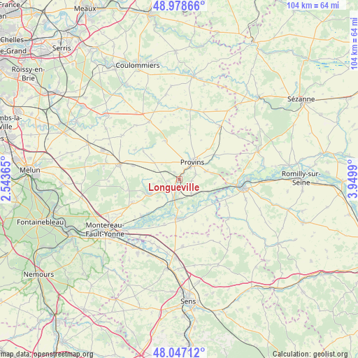
Longueville GPS coordinates[2]
48° 30' 54.108" North, 3° 14' 48.372" East
| Map corner | latitude | longitude |
|---|---|---|
| Upper-left | 48.97866°, | 2.54365° |
| Center: | 48.51503°, | 3.24677° |
| Lower-right: | 48.04712°, | 3.9499° |
| Map W x H: | 103.6×103.6 km | = 64.4×64.4mi |
| max Lat: | 51.07786° ⇑31.4% North |
| Longueville: | 48.51503° |
| min Lat: | ⇓68.6% South 41.3874° |
| min Long | Longueville | max Long |
| -5.08615° | 3.24677° | 9.52242° |
| W 61.3%⇐ | ⇒38.7% E |
Elevation
Elevation of Longueville is 72 m = 236 ft, and this is 121.7 m = 399 ft below average elevation for this country.
| Max E: |
2333 m = 7654 ft | 72.6% |
| Avg. | 193.7 m = 635 ft | |
| Longueville | 72 m = 236 ft | |
Min E: |
-1 m = -3 ft | 27.4% |
See also: France elevation on elevation.city.
Geographical zone
Longueville is located in North temperate zone (between Tropic of Cancer and the Arctic Circle). Distance of this North polar circle is 2006.8 km =1247 mi to North.| Distance of | km | miles | from Longueville |
|---|---|---|---|
| North Pole | 4612.7 | 2866.2 | to North |
| Arctic Circle | 2006.8 | 1247 | to North |
| Tropic Cancer | 2788.4 | 1732.6 | to South |
| Equator | 5394.4 | 3351.9 | to South |


Nearby cities:
15 places around Longueville: (largest is in red/bold)
• Chalautre-la-Petite
5.1 km =3.2 mi,  71°
71°
• Chalmaison
3.7 km =2.3 mi,  174°
174°
• Donnemarie-Dontilly
9.5 km =5.9 mi,  243°
243°
• Everly
5.4 km =3.4 mi,  177°
177°
• Gouaix
4.8 km =3 mi,  133°
133°
• Hermé
8.1 km =5 mi,  114°
114°
• Jutigny
2.2 km =1.4 mi,  210°
210°
• Les Ormes-sur-Voulzie
5.9 km =3.7 mi,  192°
192°
• Provins
6.2 km =3.9 mi,  38°
38°
• Saint-Brice
8.2 km =5.1 mi, 44°
• Saint-Loup-de-Naud
4 km =2.5 mi,  300°
300°
• Sainte-Colombe
1.8 km =1.1 mi,  19°
19°
• Savins
3.4 km =2.1 mi,  258°
258°
• Soisy-Bouy
3.6 km =2.2 mi,  95°
95°
• Sourdun
8.1 km =5 mi, 72°
Sources, notices
• [Note1] Compared only with cities in France existing in our database
• [Src1] Map data: © OpenStreetMap contributors (CC-BY-SA)
• [Src2] Other city data from geonames.org with taken over terms of usage.
• [Src3] Geographical zone / Annual Mean Temperature by Robert A. Rohde @ Wikipedia
