Loisy-sur-Marne geodata
Loisy-sur-Marne (Grand Est) is a populated place; located in France in Europe/Paris (GMT+2) time zone. With population of 918 people, there are 9502 cities with bigger population in this country. Compared to other cities in France, 74.6% of cities are located further ↓South; 72.4% of cities are located further ←West and 62% of cities have higher elevation than Loisy-sur-Marne. Note1
Administrative division(s):
- Level 1: Grand Est
- Level 2: Marne
- Level 3: Arrondissement de Vitry-le-François
- Level 4: Loisy-sur-Marne


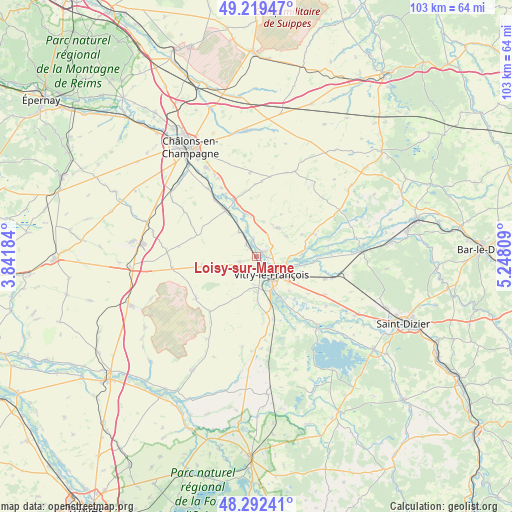
Loisy-sur-Marne GPS coordinates[2]
48° 45' 29.088" North, 4° 32' 41.856" East
| Map corner | latitude | longitude |
|---|---|---|
| Upper-left | 49.21947°, | 3.84184° |
| Center: | 48.75808°, | 4.54496° |
| Lower-right: | 48.29241°, | 5.24809° |
| Map W x H: | 103.1×103.1 km | = 64.1×64.1mi |
| max Lat: | 51.07786° ⇑25.4% North |
| Loisy-sur-Marne: | 48.75808° |
| min Lat: | ⇓74.6% South 41.3874° |
| min Long | Loisy-sur-Marne | max Long |
| -5.08615° | 4.54496° | 9.52242° |
| W 72.4%⇐ | ⇒27.6% E |
Elevation
Elevation of Loisy-sur-Marne is 97 m = 318 ft, and this is 96.7 m = 317 ft below average elevation for this country.
| Max E: |
2333 m = 7654 ft | 62% |
| Avg. | 193.7 m = 635 ft | |
| Loisy-sur-Marne | 97 m = 318 ft | |
Min E: |
-1 m = -3 ft | 38% |
See also: France elevation on elevation.city.
Geographical zone
Loisy-sur-Marne is located in North temperate zone (between Tropic of Cancer and the Arctic Circle). Distance of this North polar circle is 1979.8 km =1230.2 mi to North.| Distance of | km | miles | from Loisy-sur-Marne |
|---|---|---|---|
| North Pole | 4585.7 | 2849.4 | to North |
| Arctic Circle | 1979.8 | 1230.2 | to North |
| Tropic Cancer | 2815.5 | 1749.5 | to South |
| Equator | 5421.4 | 3368.7 | to South |


Nearby cities:
15 places around Loisy-sur-Marne: (largest is in red/bold)
• Blacy
3.7 km =2.3 mi,  169°
169°
• Couvrot
1.9 km =1.2 mi,  90°
90°
• Frignicourt
7.3 km =4.5 mi,  152°
152°
• La Chaussée-sur-Marne
8.6 km =5.3 mi,  349°
349°
• Mairy-sur-Marne
16.8 km =10.4 mi,  324°
324°
• Marolles
7.5 km =4.7 mi,  127°
127°
• Moncetz-Longevas
18.9 km =11.7 mi,  332°
332°
• Pogny
12 km =7.5 mi,  338°
338°
• Saint-Amand-sur-Fion
7.4 km =4.6 mi,  37°
37°
• Saint-Germain-la-Ville
15.5 km =9.6 mi, 332°
• Saint-Remy-en-Bouzemont-Saint-Genest-et-Isson
15.9 km =9.9 mi, 150°
• Sarry
20.5 km =12.7 mi, 330°
• Thiéblemont-Farémont
15.6 km =9.7 mi,  119°
119°
• Vitry-en-Perthois
6.1 km =3.8 mi,  100°
100°
• Vitry-le-François
4.7 km =2.9 mi,  142°
142°
Sources, notices
• [Note1] Compared only with cities in France existing in our database
• [Src1] Map data: © OpenStreetMap contributors (CC-BY-SA)
• [Src2] Other city data from geonames.org with taken over terms of usage.
• [Src3] Geographical zone / Annual Mean Temperature by Robert A. Rohde @ Wikipedia
