Livry geodata
Livry (Normandy) is a populated place; located in France in Europe/Paris (GMT+2) time zone. With population of 737 people, there are 11325 cities with bigger population in this country. Compared to other cities in France, 82.3% of cities are located further ↓South; 86.1% of cities are located further →East and 59.1% of cities have lower elevation than Livry. Note1
Administrative division(s):
- Level 1: Normandy
- Level 2: Calvados
- Level 3: Arrondissement de Vire
- Level 4: Caumont-sur-Aure


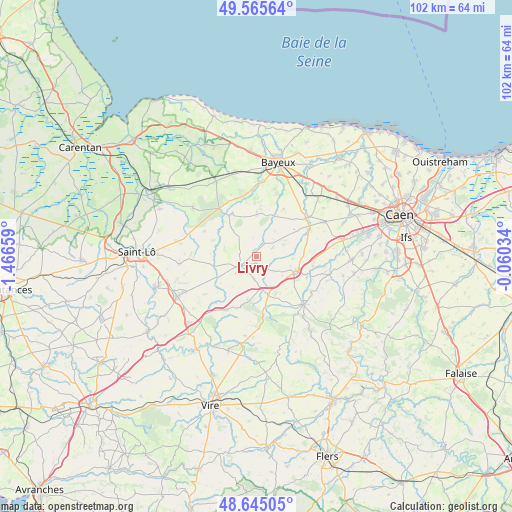
Livry GPS coordinates[2]
49° 6' 26.928" North, 0° 45' 48.456" West
| Map corner | latitude | longitude |
|---|---|---|
| Upper-left | 49.56564°, | -1.46659° |
| Center: | 49.10748°, | -0.76346° |
| Lower-right: | 48.64505°, | -0.06034° |
| Map W x H: | 102.4×102.4 km | = 63.6×63.6mi |
| max Lat: | 51.07786° ⇑17.7% North |
| Livry: | 49.10748° |
| min Lat: | ⇓82.3% South 41.3874° |
| min Long | Livry | max Long |
| -5.08615° | -0.76346° | 9.52242° |
| W 13.9%⇐ | ⇒86.1% E |
Elevation
Elevation of Livry is 166 m = 545 ft, and this is 27.7 m = 91 ft below average elevation for this country.
| Max E: |
2333 m = 7654 ft | 40.9% |
| Avg. | 193.7 m = 635 ft | |
| Livry | 166 m = 545 ft | |
Min E: |
-1 m = -3 ft | 59.1% |
See also: France elevation on elevation.city.
Geographical zone
Livry is located in North temperate zone (between Tropic of Cancer and the Arctic Circle). Distance of this North polar circle is 1940.9 km =1206 mi to North.| Distance of | km | miles | from Livry |
|---|---|---|---|
| North Pole | 4546.8 | 2825.2 | to North |
| Arctic Circle | 1940.9 | 1206 | to North |
| Tropic Cancer | 2854.3 | 1773.6 | to South |
| Equator | 5460.2 | 3392.8 | to South |


Nearby cities:
15 places around Livry: (largest is in red/bold)
• Anctoville
4.2 km =2.6 mi,  93°
93°
• Aunay-sur-Odon
13.6 km =8.5 mi,  135°
135°
• Balleroy
9.8 km =6.1 mi,  326°
326°
• Cahagnes
4.6 km =2.9 mi,  184°
184°
• Caumont-l'Éventé
3.6 km =2.2 mi,  237°
237°
• Juaye-Mondaye
12.7 km =7.9 mi,  22°
22°
• Jurques
10.1 km =6.3 mi,  170°
170°
• Le Tronquay
13.8 km =8.6 mi,  342°
342°
• Noyers-Bocage
14.4 km =8.9 mi,  83°
83°
• Saint-Martin-des-Besaces
12.3 km =7.6 mi,  208°
208°
• Saint-Paul-du-Vernay
9 km =5.6 mi,  0°
0°
• Tilly-sur-Seulles
12.6 km =7.8 mi,  52°
52°
• Villers-Bocage
8.5 km =5.3 mi,  111°
111°
• Villy-Bocage
8.9 km =5.5 mi,  98°
98°
• Épinay-sur-Odon
11 km =6.8 mi, 108°
Sources, notices
• [Note1] Compared only with cities in France existing in our database
• [Src1] Map data: © OpenStreetMap contributors (CC-BY-SA)
• [Src2] Other city data from geonames.org with taken over terms of usage.
• [Src3] Geographical zone / Annual Mean Temperature by Robert A. Rohde @ Wikipedia
