Caumont-l'Éventé geodata
Caumont-l'Éventé (Normandy) is a populated place; located in France in Europe/Paris (GMT+2) time zone. With population of 1,348 people, there are 6822 cities with bigger population in this country. Compared to other cities in France, 81.9% of cities are located further ↓South; 86.5% of cities are located further →East and 74% of cities have lower elevation than Caumont-l'Éventé. Note1
Administrative division(s):
- Level 1: Normandy
- Level 2: Calvados
- Level 3: Arrondissement de Vire
- Level 4: Caumont-sur-Aure


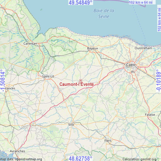
Caumont-l'Éventé GPS coordinates[2]
49° 5' 24.612" North, 0° 48' 18.036" West
| Map corner | latitude | longitude |
|---|---|---|
| Upper-left | 49.54849°, | -1.50814° |
| Center: | 49.09017°, | -0.80501° |
| Lower-right: | 48.62758°, | -0.10189° |
| Map W x H: | 102.4×102.4 km | = 63.6×63.6mi |
| max Lat: | 51.07786° ⇑18.1% North |
| Caumont-l'Éventé: | 49.09017° |
| min Lat: | ⇓81.9% South 41.3874° |
| min Long | Caumont-l'Éven | max Long |
| -5.08615° | -0.80501° | 9.52242° |
| W 13.5%⇐ | ⇒86.5% E |
Elevation
Elevation of Caumont-l'Éventé is 242 m = 794 ft, and this is 48.3 m = 158 ft above average elevation for this country.
| Max E: |
2333 m = 7654 ft | 26% |
| Caumont-l'Éventé | 242 m 794 ft | |
| Avg. | 193.7 m = 635 ft | |
Min E: |
-1 m = -3 ft | 74% |
See also: France elevation on elevation.city.
Geographical zone
Caumont-l'Éventé is located in North temperate zone (between Tropic of Cancer and the Arctic Circle). Distance of this North polar circle is 1942.9 km =1207.3 mi to North.| Distance of | km | miles | from Caumont-l'Éventé |
|---|---|---|---|
| North Pole | 4548.7 | 2826.4 | to North |
| Arctic Circle | 1942.9 | 1207.3 | to North |
| Tropic Cancer | 2852.4 | 1772.4 | to South |
| Equator | 5458.3 | 3391.6 | to South |


Nearby cities:
15 places around Caumont-l'Éventé: (largest is in red/bold)
• Anctoville
7.4 km =4.6 mi,  76°
76°
• Aunay-sur-Odon
14.8 km =9.2 mi,  121°
121°
• Balleroy
10.4 km =6.5 mi,  346°
346°
• Cahagnes
3.7 km =2.3 mi,  135°
135°
• Jurques
9.3 km =5.8 mi,  149°
149°
• Le Tourneur
14.1 km =8.8 mi,  184°
184°
• Livry
3.6 km =2.2 mi,  57°
57°
• Saint-Amand
12.8 km =8 mi,  245°
245°
• Saint-Jean-des-Baisants
12.2 km =7.6 mi,  271°
271°
• Saint-Martin-des-Besaces
9.3 km =5.8 mi,  198°
198°
• Saint-Paul-du-Vernay
11.4 km =7.1 mi,  16°
16°
• Torigni-sur-Vire
14.2 km =8.8 mi, 245°
• Villers-Bocage
11.1 km =6.9 mi,  96°
96°
• Villy-Bocage
11.8 km =7.3 mi,  87°
87°
• Épinay-sur-Odon
13.5 km =8.4 mi, 96°
Sources, notices
• [Note1] Compared only with cities in France existing in our database
• [Src1] Map data: © OpenStreetMap contributors (CC-BY-SA)
• [Src2] Other city data from geonames.org with taken over terms of usage.
• [Src3] Geographical zone / Annual Mean Temperature by Robert A. Rohde @ Wikipedia
