Saint-Paul-du-Vernay geodata
Saint-Paul-du-Vernay (Normandy) is a populated place; located in France in Europe/Paris (GMT+2) time zone. With population of 668 people, there are 12251 cities with bigger population in this country. Compared to other cities in France, 84.1% of cities are located further ↓South; 86.1% of cities are located further →East and 52% of cities have higher elevation than Saint-Paul-du-Vernay. Note1
Administrative division(s):
- Level 1: Normandy
- Level 2: Calvados
- Level 3: Arrondissement de Bayeux
- Level 4: Saint-Paul-du-Vernay


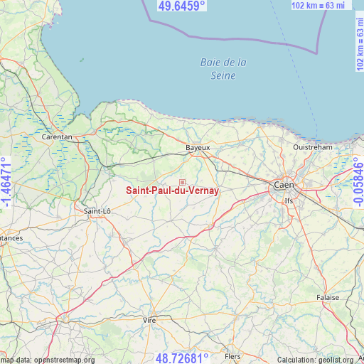
Saint-Paul-du-Vernay GPS coordinates[2]
49° 11' 18.564" North, 0° 45' 41.688" West
| Map corner | latitude | longitude |
|---|---|---|
| Upper-left | 49.6459°, | -1.46471° |
| Center: | 49.18849°, | -0.76158° |
| Lower-right: | 48.72681°, | -0.05846° |
| Map W x H: | 102.2×102.2 km | = 63.5×63.5mi |
| max Lat: | 51.07786° ⇑15.9% North |
| Saint-Paul-du-Vernay: | 49.18849° |
| min Lat: | ⇓84.1% South 41.3874° |
| min Long | Saint-Paul-du-V | max Long |
| -5.08615° | -0.76158° | 9.52242° |
| W 13.9%⇐ | ⇒86.1% E |
Elevation
Elevation of Saint-Paul-du-Vernay is 125 m = 410 ft, and this is 68.7 m = 225 ft below average elevation for this country.
| Max E: |
2333 m = 7654 ft | 52% |
| Avg. | 193.7 m = 635 ft | |
| Saint-Paul-du-Vernay | 125 m = 410 ft | |
Min E: |
-1 m = -3 ft | 48% |
See also: France elevation on elevation.city.
Geographical zone
Saint-Paul-du-Vernay is located in North temperate zone (between Tropic of Cancer and the Arctic Circle). Distance of this North polar circle is 1931.9 km =1200.4 mi to North.| Distance of | km | miles | from Saint-Paul-du-Vernay |
|---|---|---|---|
| North Pole | 4537.8 | 2819.7 | to North |
| Arctic Circle | 1931.9 | 1200.4 | to North |
| Tropic Cancer | 2863.3 | 1779.2 | to South |
| Equator | 5469.2 | 3398.4 | to South |


Nearby cities:
15 places around Saint-Paul-du-Vernay: (largest is in red/bold)
• Anctoville
10.1 km =6.3 mi,  156°
156°
• Audrieu
12.4 km =7.7 mi,  79°
79°
• Balleroy
5.6 km =3.5 mi,  261°
261°
• Bayeux
10.7 km =6.6 mi,  22°
22°
• Caumont-l'Éventé
11.4 km =7.1 mi,  196°
196°
• Cerisy-la-Forêt
12.8 km =8 mi,  273°
273°
• Juaye-Mondaye
5.4 km =3.4 mi,  59°
59°
• Le Molay-Littry
10.1 km =6.3 mi,  306°
306°
• Le Tronquay
5.9 km =3.7 mi, 314°
• Livry
9 km =5.6 mi,  180°
180°
• Saint-Martin-des-Entrées
10.9 km =6.8 mi,  36°
36°
• Saint-Vigor-le-Grand
11.8 km =7.3 mi,  27°
27°
• Subles
5.8 km =3.6 mi,  7°
7°
• Tilly-sur-Seulles
9.9 km =6.2 mi,  98°
98°
• Tour-en-Bessin
12.2 km =7.6 mi,  354°
354°
Sources, notices
• [Note1] Compared only with cities in France existing in our database
• [Src1] Map data: © OpenStreetMap contributors (CC-BY-SA)
• [Src2] Other city data from geonames.org with taken over terms of usage.
• [Src3] Geographical zone / Annual Mean Temperature by Robert A. Rohde @ Wikipedia
