Balleroy geodata
Balleroy (Normandy) is a populated place; located in France in Europe/Paris (GMT+2) time zone. With population of 871 people, there are 9891 cities with bigger population in this country. Compared to other cities in France, 83.9% of cities are located further ↓South; 86.8% of cities are located further →East and 61.5% of cities have higher elevation than Balleroy. Note1
Administrative division(s):
- Level 1: Normandy
- Level 2: Calvados
- Level 3: Arrondissement de Bayeux
- Level 4: Balleroy-sur-Drôme


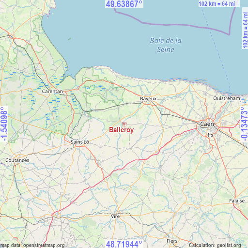
Balleroy GPS coordinates[2]
49° 10' 52.284" North, 0° 50' 16.26" West
| Map corner | latitude | longitude |
|---|---|---|
| Upper-left | 49.63867°, | -1.54098° |
| Center: | 49.18119°, | -0.83785° |
| Lower-right: | 48.71944°, | -0.13473° |
| Map W x H: | 102.2×102.2 km | = 63.5×63.5mi |
| max Lat: | 51.07786° ⇑16.1% North |
| Balleroy: | 49.18119° |
| min Lat: | ⇓83.9% South 41.3874° |
| min Long | Balleroy | max Long |
| -5.08615° | -0.83785° | 9.52242° |
| W 13.2%⇐ | ⇒86.8% E |
Elevation
Elevation of Balleroy is 98 m = 322 ft, and this is 95.7 m = 314 ft below average elevation for this country.
| Max E: |
2333 m = 7654 ft | 61.5% |
| Avg. | 193.7 m = 635 ft | |
| Balleroy | 98 m = 322 ft | |
Min E: |
-1 m = -3 ft | 38.5% |
See also: France elevation on elevation.city.
Geographical zone
Balleroy is located in North temperate zone (between Tropic of Cancer and the Arctic Circle). Distance of this North polar circle is 1932.7 km =1200.9 mi to North.| Distance of | km | miles | from Balleroy |
|---|---|---|---|
| North Pole | 4538.6 | 2820.2 | to North |
| Arctic Circle | 1932.7 | 1200.9 | to North |
| Tropic Cancer | 2862.5 | 1778.7 | to South |
| Equator | 5468.4 | 3397.9 | to South |


Nearby cities:
15 places around Balleroy: (largest is in red/bold)
• Anctoville
12.7 km =7.9 mi,  131°
131°
• Bayeux
14.5 km =9 mi,  42°
42°
• Cahagnes
13.7 km =8.5 mi,  158°
158°
• Caumont-l'Éventé
10.4 km =6.5 mi,  166°
166°
• Cerisy-la-Forêt
7.3 km =4.5 mi,  281°
281°
• Juaye-Mondaye
10.8 km =6.7 mi,  70°
70°
• Le Molay-Littry
7.3 km =4.5 mi,  339°
339°
• Le Tronquay
5.1 km =3.2 mi,  14°
14°
• Livry
9.8 km =6.1 mi,  146°
146°
• Saint-Clair-sur-l'Elle
13.9 km =8.6 mi, 275°
• Saint-Jean-des-Baisants
13.8 km =8.6 mi,  225°
225°
• Saint-Paul-du-Vernay
5.6 km =3.5 mi,  81°
81°
• Subles
9.1 km =5.7 mi, 43°
• Tour-en-Bessin
13.7 km =8.5 mi,  18°
18°
• Trévières
15 km =9.3 mi, 341°
Sources, notices
• [Note1] Compared only with cities in France existing in our database
• [Src1] Map data: © OpenStreetMap contributors (CC-BY-SA)
• [Src2] Other city data from geonames.org with taken over terms of usage.
• [Src3] Geographical zone / Annual Mean Temperature by Robert A. Rohde @ Wikipedia
