Listrac-Médoc geodata
Listrac-Médoc (Nouvelle-Aquitaine) is a populated place; located in France in Europe/Paris (GMT+2) time zone. With population of 2,002 people, there are 4788 cities with bigger population in this country. Compared to other cities in France, 78.8% of cities are located further ↑North; 86.4% of cities are located further →East and 85.9% of cities have higher elevation than Listrac-Médoc. Note1
Administrative division(s):
- Level 1: Nouvelle-Aquitaine
- Level 2: Gironde
- Level 3: Arrondissement de Lesparre-Médoc
- Level 4: Listrac-Médoc


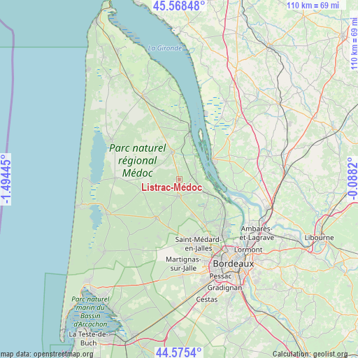
Listrac-Médoc GPS coordinates[2]
45° 4' 26.76" North, 0° 47' 28.752" West
| Map corner | latitude | longitude |
|---|---|---|
| Upper-left | 45.56848°, | -1.49445° |
| Center: | 45.0741°, | -0.79132° |
| Lower-right: | 44.5754°, | -0.0882° |
| Map W x H: | 110.4×110.4 km | = 68.6×68.6mi |
| max Lat: | 51.07786° ⇑78.8% North |
| Listrac-Médoc: | 45.0741° |
| min Lat: | ⇓21.2% South 41.3874° |
| min Long | Listrac-Médoc | max Long |
| -5.08615° | -0.79132° | 9.52242° |
| W 13.6%⇐ | ⇒86.4% E |
Elevation
Elevation of Listrac-Médoc is 40 m = 131 ft, and this is 153.7 m = 504 ft below average elevation for this country.
| Max E: |
2333 m = 7654 ft | 85.9% |
| Avg. | 193.7 m = 635 ft | |
| Listrac-Médoc | 40 m = 131 ft | |
Min E: |
-1 m = -3 ft | 14.1% |
See also: France elevation on elevation.city.
Geographical zone
Listrac-Médoc is located in North temperate zone (between Tropic of Cancer and the Arctic Circle). Distance of this North polar circle is 2389.4 km =1484.7 mi to North.| Distance of | km | miles | from Listrac-Médoc |
|---|---|---|---|
| North Pole | 4995.3 | 3103.9 | to North |
| Arctic Circle | 2389.4 | 1484.7 | to North |
| Tropic Cancer | 2405.9 | 1495 | to South |
| Equator | 5011.8 | 3114.2 | to South |


Nearby cities:
15 places around Listrac-Médoc: (largest is in red/bold)
• Arsac
11.7 km =7.3 mi,  137°
137°
• Avensan
5.2 km =3.2 mi,  147°
147°
• Blaye
11.8 km =7.3 mi,  59°
59°
• Cantenac
12 km =7.5 mi,  115°
115°
• Castelnau-de-Médoc
5 km =3.1 mi,  186°
186°
• Cussac-Fort-Médoc
6.6 km =4.1 mi,  43°
43°
• Gauriac
14 km =8.7 mi,  93°
93°
• Labarde
13.6 km =8.5 mi, 118°
• Lamarque
6.2 km =3.9 mi,  67°
67°
• Margaux
9.6 km =6 mi,  113°
113°
• Moulis-en-Médoc
2.3 km =1.4 mi,  134°
134°
• Pauillac
14 km =8.7 mi,  13°
13°
• Plassac
11.9 km =7.4 mi, 74°
• Saint-Julien-Beychevelle
11 km =6.8 mi,  20°
20°
• Soussans
7.5 km =4.7 mi, 105°
Sources, notices
• [Note1] Compared only with cities in France existing in our database
• [Src1] Map data: © OpenStreetMap contributors (CC-BY-SA)
• [Src2] Other city data from geonames.org with taken over terms of usage.
• [Src3] Geographical zone / Annual Mean Temperature by Robert A. Rohde @ Wikipedia
