Plassac geodata
Plassac (Nouvelle-Aquitaine) is a populated place; located in France in Europe/Paris (GMT+2) time zone. With population of 959 people, there are 9134 cities with bigger population in this country. Compared to other cities in France, 78.5% of cities are located further ↑North; 85% of cities are located further →East and 96.3% of cities have higher elevation than Plassac. Note1
Administrative division(s):
- Level 1: Nouvelle-Aquitaine
- Level 2: Gironde
- Level 3: Arrondissement de Blaye
- Level 4: Plassac


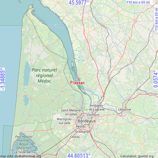
Plassac GPS coordinates[2]
45° 6' 12.852" North, 0° 38' 44.592" West
| Map corner | latitude | longitude |
|---|---|---|
| Upper-left | 45.5977°, | -1.34885° |
| Center: | 45.10357°, | -0.64572° |
| Lower-right: | 44.60513°, | 0.0574° |
| Map W x H: | 110.4×110.4 km | = 68.6×68.6mi |
| max Lat: | 51.07786° ⇑78.5% North |
| Plassac: | 45.10357° |
| min Lat: | ⇓21.5% South 41.3874° |
| min Long | Plassac | max Long |
| -5.08615° | -0.64572° | 9.52242° |
| W 15%⇐ | ⇒85% E |
Elevation
Elevation of Plassac is 13 m = 43 ft, and this is 180.7 m = 593 ft below average elevation for this country.
| Max E: |
2333 m = 7654 ft | 96.3% |
| Avg. | 193.7 m = 635 ft | |
| Plassac | 13 m = 43 ft | |
Min E: |
-1 m = -3 ft | 3.7% |
See also: France elevation on elevation.city.
Geographical zone
Plassac is located in North temperate zone (between Tropic of Cancer and the Arctic Circle). Distance of this North polar circle is 2386.1 km =1482.7 mi to North.| Distance of | km | miles | from Plassac |
|---|---|---|---|
| North Pole | 4992 | 3101.9 | to North |
| Arctic Circle | 2386.1 | 1482.7 | to North |
| Tropic Cancer | 2409.1 | 1496.9 | to South |
| Equator | 5015 | 3116.2 | to South |


Nearby cities:
15 places around Plassac: (largest is in red/bold)
• Bayon-sur-Gironde
7.7 km =4.8 mi,  140°
140°
• Berson
4.6 km =2.9 mi,  85°
85°
• Blaye
3 km =1.9 mi,  334°
334°
• Cantenac
8.4 km =5.2 mi,  183°
183°
• Cars
3.5 km =2.2 mi,  35°
35°
• Cussac-Fort-Médoc
7 km =4.3 mi,  281°
281°
• Gauriac
4.9 km =3 mi,  149°
149°
• Lamarque
5.8 km =3.6 mi,  260°
260°
• Margaux
7.5 km =4.7 mi,  200°
200°
• Saint-Ciers-de-Canesse
3.6 km =2.2 mi,  127°
127°
• Saint-Martin-Lacaussade
4.8 km =3 mi,  2°
2°
• Saint-Paul
5.9 km =3.7 mi,  33°
33°
• Saint-Seurin-de-Cursac
6.6 km =4.1 mi,  15°
15°
• Soussans
6.7 km =4.2 mi,  218°
218°
• Teuillac
7.8 km =4.8 mi,  99°
99°
Sources, notices
• [Note1] Compared only with cities in France existing in our database
• [Src1] Map data: © OpenStreetMap contributors (CC-BY-SA)
• [Src2] Other city data from geonames.org with taken over terms of usage.
• [Src3] Geographical zone / Annual Mean Temperature by Robert A. Rohde @ Wikipedia
