Blaye geodata
Blaye (Nouvelle-Aquitaine) is a seat of a third-order administrative division; located in France in Europe/Paris (GMT+2) time zone. With population of 5,277 people, there are 1866 cities with bigger population in this country. Compared to other cities in France, 78.2% of cities are located further ↑North; 85.1% of cities are located further →East and 97.4% of cities have higher elevation than Blaye. Note1
Administrative division(s):
- Level 1: Nouvelle-Aquitaine
- Level 2: Gironde
- Level 3: Arrondissement de Blaye
- Level 4: Blaye


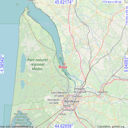
Blaye GPS coordinates[2]
45° 7' 40.152" North, 0° 39' 44.28" West
| Map corner | latitude | longitude |
|---|---|---|
| Upper-left | 45.62174°, | -1.36542° |
| Center: | 45.12782°, | -0.6623° |
| Lower-right: | 44.62959°, | 0.04083° |
| Map W x H: | 110.3×110.3 km | = 68.5×68.5mi |
| max Lat: | 51.07786° ⇑78.2% North |
| Blaye: | 45.12782° |
| min Lat: | ⇓21.8% South 41.3874° |
| min Long | Blaye | max Long |
| -5.08615° | -0.6623° | 9.52242° |
| W 14.9%⇐ | ⇒85.1% E |
Elevation
Elevation of Blaye is 10 m = 33 ft, and this is 183.7 m = 603 ft below average elevation for this country.
| Max E: |
2333 m = 7654 ft | 97.4% |
| Avg. | 193.7 m = 635 ft | |
| Blaye | 10 m = 33 ft | |
Min E: |
-1 m = -3 ft | 2.6% |
See also: France elevation on elevation.city.
Geographical zone
Blaye is located in North temperate zone (between Tropic of Cancer and the Arctic Circle). Distance of this North polar circle is 2383.4 km =1481 mi to North.| Distance of | km | miles | from Blaye |
|---|---|---|---|
| North Pole | 4989.3 | 3100.2 | to North |
| Arctic Circle | 2383.4 | 1481 | to North |
| Tropic Cancer | 2411.8 | 1498.6 | to South |
| Equator | 5017.7 | 3117.9 | to South |


Nearby cities:
15 places around Blaye: (largest is in red/bold)
• Berson
6.3 km =3.9 mi,  111°
111°
• Cars
3.4 km =2.1 mi,  87°
87°
• Cartelègue
9 km =5.6 mi,  44°
44°
• Cussac-Fort-Médoc
5.7 km =3.5 mi,  257°
257°
• Eyrans
7.6 km =4.7 mi,  28°
28°
• Gauriac
7.9 km =4.9 mi,  151°
151°
• Lamarque
5.7 km =3.5 mi,  230°
230°
• Plassac
3 km =1.9 mi, 154°
• Saint-Androny
6.9 km =4.3 mi,  8°
8°
• Saint-Ciers-de-Canesse
6.5 km =4 mi,  139°
139°
• Saint-Julien-Beychevelle
7.6 km =4.7 mi,  304°
304°
• Saint-Martin-Lacaussade
2.5 km =1.6 mi, 36°
• Saint-Paul
5.1 km =3.2 mi,  63°
63°
• Saint-Seurin-de-Cursac
4.8 km =3 mi, 40°
• Soussans
8.5 km =5.3 mi,  199°
199°
Sources, notices
• [Note1] Compared only with cities in France existing in our database
• [Src1] Map data: © OpenStreetMap contributors (CC-BY-SA)
• [Src2] Other city data from geonames.org with taken over terms of usage.
• [Src3] Geographical zone / Annual Mean Temperature by Robert A. Rohde @ Wikipedia
