Soussans geodata
Soussans (Nouvelle-Aquitaine) is a populated place; located in France in Europe/Paris (GMT+2) time zone. With population of 1,460 people, there are 6333 cities with bigger population in this country. Compared to other cities in France, 79% of cities are located further ↑North; 85.5% of cities are located further →East and 96.3% of cities have higher elevation than Soussans. Note1
Administrative division(s):
- Level 1: Nouvelle-Aquitaine
- Level 2: Gironde
- Level 3: Arrondissement de Lesparre-Médoc
- Level 4: Soussans


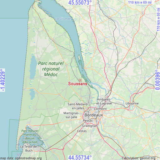
Soussans GPS coordinates[2]
45° 3' 22.284" North, 0° 41' 56.976" West
| Map corner | latitude | longitude |
|---|---|---|
| Upper-left | 45.55073°, | -1.40229° |
| Center: | 45.05619°, | -0.69916° |
| Lower-right: | 44.55734°, | 0.00396° |
| Map W x H: | 110.5×110.5 km | = 68.7×68.7mi |
| max Lat: | 51.07786° ⇑79% North |
| Soussans: | 45.05619° |
| min Lat: | ⇓21% South 41.3874° |
| min Long | Soussans | max Long |
| -5.08615° | -0.69916° | 9.52242° |
| W 14.5%⇐ | ⇒85.5% E |
Elevation
Elevation of Soussans is 13 m = 43 ft, and this is 180.7 m = 593 ft below average elevation for this country.
| Max E: |
2333 m = 7654 ft | 96.3% |
| Avg. | 193.7 m = 635 ft | |
| Soussans | 13 m = 43 ft | |
Min E: |
-1 m = -3 ft | 3.7% |
See also: France elevation on elevation.city.
Geographical zone
Soussans is located in North temperate zone (between Tropic of Cancer and the Arctic Circle). Distance of this North polar circle is 2391.4 km =1485.9 mi to North.| Distance of | km | miles | from Soussans |
|---|---|---|---|
| North Pole | 4997.3 | 3105.2 | to North |
| Arctic Circle | 2391.4 | 1485.9 | to North |
| Tropic Cancer | 2403.9 | 1493.7 | to South |
| Equator | 5009.8 | 3112.9 | to South |


Nearby cities:
15 places around Soussans: (largest is in red/bold)
• Arsac
6.6 km =4.1 mi,  173°
173°
• Avensan
5.1 km =3.2 mi,  241°
241°
• Blaye
8.5 km =5.3 mi,  19°
19°
• Cantenac
4.8 km =3 mi,  130°
130°
• Castelnau-de-Médoc
8.3 km =5.2 mi,  249°
249°
• Cussac-Fort-Médoc
7.2 km =4.5 mi,  338°
338°
• Gauriac
6.8 km =4.2 mi,  81°
81°
• Labarde
6.5 km =4 mi, 133°
• Lamarque
4.6 km =2.9 mi, 340°
• Listrac-Médoc
7.5 km =4.7 mi,  285°
285°
• Macau
8.4 km =5.2 mi, 130°
• Margaux
2.4 km =1.5 mi,  138°
138°
• Moulis-en-Médoc
5.6 km =3.5 mi,  273°
273°
• Plassac
6.7 km =4.2 mi,  38°
38°
• Saint-Ciers-de-Canesse
7.7 km =4.8 mi,  66°
66°
Sources, notices
• [Note1] Compared only with cities in France existing in our database
• [Src1] Map data: © OpenStreetMap contributors (CC-BY-SA)
• [Src2] Other city data from geonames.org with taken over terms of usage.
• [Src3] Geographical zone / Annual Mean Temperature by Robert A. Rohde @ Wikipedia
