L’Isle-d’Abeau geodata
L’Isle-d’Abeau (Auvergne-Rhône-Alpes) is a populated place; located in France in Europe/Paris (GMT+2) time zone. With population of 12,033 people, there are 798 cities with bigger population in this country. Compared to other cities in France, 72.2% of cities are located further ↑North; 80% of cities are located further ←West and 72.4% of cities have lower elevation than L’Isle-d’Abeau. Note1
Administrative division(s):
- Level 1: Auvergne-Rhône-Alpes
- Level 2: Département de l'Isère
- Level 3: Arrondissement de La Tour-du-Pin
- Level 4: L'Isle-d'Abeau


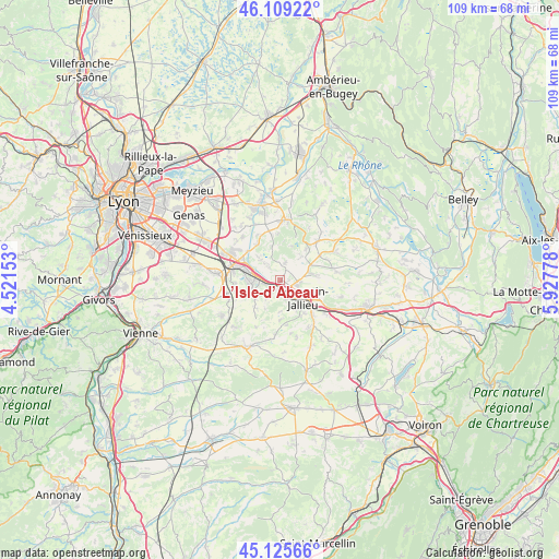
L’Isle-d’Abeau GPS coordinates[2]
45° 37' 10.56" North, 5° 13' 28.776" East
| Map corner | latitude | longitude |
|---|---|---|
| Upper-left | 46.10922°, | 4.52153° |
| Center: | 45.6196°, | 5.22466° |
| Lower-right: | 45.12566°, | 5.92778° |
| Map W x H: | 109.4×109.4 km | = 68×68mi |
| max Lat: | 51.07786° ⇑72.2% North |
| L’Isle-d’Abeau: | 45.6196° |
| min Lat: | ⇓27.8% South 41.3874° |
| min Long | L’Isle-d’Ab | max Long |
| -5.08615° | 5.22466° | 9.52242° |
| W 80%⇐ | ⇒20% E |
Elevation
Elevation of L’Isle-d’Abeau is 232 m = 761 ft, and this is 38.3 m = 126 ft above average elevation for this country.
| Max E: |
2333 m = 7654 ft | 27.6% |
| L’Isle-d’Abeau | 232 m 761 ft | |
| Avg. | 193.7 m = 635 ft | |
Min E: |
-1 m = -3 ft | 72.4% |
See also: France elevation on elevation.city.
Geographical zone
L’Isle-d’Abeau is located in North temperate zone (between Tropic of Cancer and the Arctic Circle). Distance of this North polar circle is 2328.8 km =1447 mi to North.| Distance of | km | miles | from L’Isle-d’Abeau |
|---|---|---|---|
| North Pole | 4934.6 | 3066.2 | to North |
| Arctic Circle | 2328.8 | 1447 | to North |
| Tropic Cancer | 2466.5 | 1532.6 | to South |
| Equator | 5072.4 | 3151.8 | to South |


Nearby cities:
15 places around L’Isle-d’Abeau: (largest is in red/bold)
• Bonnefamille
8.1 km =5 mi,  253°
253°
• Bourgoin-Jallieu
5.3 km =3.3 mi,  134°
134°
• Chamagnieu
8.2 km =5.1 mi,  328°
328°
• Domarin
4 km =2.5 mi,  155°
155°
• Four
4.4 km =2.7 mi,  213°
213°
• Frontonas
3.5 km =2.2 mi,  322°
322°
• La Verpillière
6.4 km =4 mi,  284°
284°
• Maubec
6.6 km =4.1 mi,  152°
152°
• Panossas
6.6 km =4.1 mi,  345°
345°
• Roche
6 km =3.7 mi,  233°
233°
• Ruy
8.4 km =5.2 mi,  116°
116°
• Saint-Alban-de-Roche
2.7 km =1.7 mi,  177°
177°
• Saint-Savin
6.6 km =4.1 mi,  82°
82°
• Vaulx-Milieu
3.3 km =2.1 mi,  257°
257°
• Villefontaine
5.8 km =3.6 mi, 262°
Sources, notices
• [Note1] Compared only with cities in France existing in our database
• [Src1] Map data: © OpenStreetMap contributors (CC-BY-SA)
• [Src2] Other city data from geonames.org with taken over terms of usage.
• [Src3] Geographical zone / Annual Mean Temperature by Robert A. Rohde @ Wikipedia
