Ruy geodata
Ruy (Auvergne-Rhône-Alpes) is a populated place; located in France in Europe/Paris (GMT+2) time zone. With population of 4,090 people, there are 2403 cities with bigger population in this country. Compared to other cities in France, 72.8% of cities are located further ↑North; 80.8% of cities are located further ←West and 82.3% of cities have lower elevation than Ruy. Note1
Administrative division(s):
- Level 1: Auvergne-Rhône-Alpes
- Level 2: Département de l'Isère
- Level 3: Arrondissement de La Tour-du-Pin
- Level 4: Ruy-Montceau


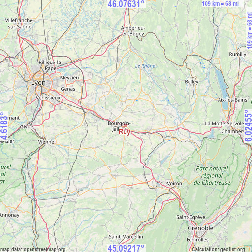
Ruy GPS coordinates[2]
45° 35' 11.04" North, 5° 19' 17.148" East
| Map corner | latitude | longitude |
|---|---|---|
| Upper-left | 46.07631°, | 4.6183° |
| Center: | 45.5864°, | 5.32143° |
| Lower-right: | 45.09217°, | 6.02455° |
| Map W x H: | 109.4×109.4 km | = 68×68mi |
| max Lat: | 51.07786° ⇑72.8% North |
| Ruy: | 45.5864° |
| min Lat: | ⇓27.2% South 41.3874° |
| min Long | Ruy | max Long |
| -5.08615° | 5.32143° | 9.52242° |
| W 80.8%⇐ | ⇒19.2% E |
Elevation
Elevation of Ruy is 313 m = 1027 ft, and this is 119.3 m = 391 ft above average elevation for this country.
| Max E: |
2333 m = 7654 ft | 17.7% |
| Ruy | 313 m 1027 ft | |
| Avg. | 193.7 m = 635 ft | |
Min E: |
-1 m = -3 ft | 82.3% |
See also: France elevation on elevation.city.
Geographical zone
Ruy is located in North temperate zone (between Tropic of Cancer and the Arctic Circle). Distance of this North polar circle is 2332.4 km =1449.3 mi to North.| Distance of | km | miles | from Ruy |
|---|---|---|---|
| North Pole | 4938.3 | 3068.5 | to North |
| Arctic Circle | 2332.4 | 1449.3 | to North |
| Tropic Cancer | 2462.8 | 1530.3 | to South |
| Equator | 5068.7 | 3149.5 | to South |


Nearby cities:
15 places around Ruy: (largest is in red/bold)
• Bourgoin-Jallieu
3.7 km =2.3 mi,  269°
269°
• Cessieu
4.9 km =3 mi,  120°
120°
• Châteauvilain
8 km =5 mi,  175°
175°
• Domarin
5.9 km =3.7 mi, 270°
• Les Éparres
5.9 km =3.7 mi,  200°
200°
• Maubec
5 km =3.1 mi,  244°
244°
• Meyrié
4.1 km =2.5 mi,  220°
220°
• Nivolas-Vermelle
3.3 km =2.1 mi, 201°
• Rochetoirin
7.1 km =4.4 mi,  92°
92°
• Saint-Alban-de-Roche
7.5 km =4.7 mi,  277°
277°
• Saint-Chef
6.4 km =4 mi,  31°
31°
• Saint-Savin
4.7 km =2.9 mi,  347°
347°
• Saint-Victor-de-Cessieu
7.4 km =4.6 mi,  132°
132°
• Succieu
6.7 km =4.2 mi,  168°
168°
• Sérézin-de-la-Tour
4 km =2.5 mi,  148°
148°
Sources, notices
• [Note1] Compared only with cities in France existing in our database
• [Src1] Map data: © OpenStreetMap contributors (CC-BY-SA)
• [Src2] Other city data from geonames.org with taken over terms of usage.
• [Src3] Geographical zone / Annual Mean Temperature by Robert A. Rohde @ Wikipedia
