Auterive geodata
Auterive (Occitanie) is a populated place; located in France in Europe/Paris (GMT+2) time zone. With population of 7,369 people, there are 1330 cities with bigger population in this country. Compared to other cities in France, 94.8% of cities are located further ↑North; 63.3% of cities are located further →East and 65% of cities have lower elevation than Auterive. Note1
Administrative division(s):
- Level 1: Occitanie
- Level 2: Haute-Garonne
- Level 3: Arrondissement de Muret
- Level 4: Auterive


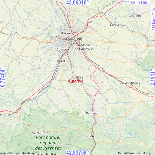
Auterive GPS coordinates[2]
43° 21' 3.708" North, 1° 28' 40.692" East
| Map corner | latitude | longitude |
|---|---|---|
| Upper-left | 43.86016°, | 0.77484° |
| Center: | 43.35103°, | 1.47797° |
| Lower-right: | 42.83759°, | 2.1811° |
| Map W x H: | 113.7×113.7 km | = 70.6×70.6mi |
| max Lat: | 51.07786° ⇑94.8% North |
| Auterive: | 43.35103° |
| min Lat: | ⇓5.2% South 41.3874° |
| min Long | Auterive | max Long |
| -5.08615° | 1.47797° | 9.52242° |
| W 36.7%⇐ | ⇒63.3% E |
Elevation
Elevation of Auterive is 194 m = 636 ft, and this is 0.30000000000001 m = 1 ft above average elevation for this country.
| Max E: |
2333 m = 7654 ft | 35% |
| Auterive | 194 m 636 ft | |
| Avg. | 193.7 m = 635 ft | |
Min E: |
-1 m = -3 ft | 65% |
See also: France elevation on elevation.city.
Geographical zone
Auterive is located in North temperate zone (between Tropic of Cancer and the Arctic Circle). Distance of this Northern Tropic circle is 2214.3 km =1375.9 mi to South.| Distance of | km | miles | from Auterive |
|---|---|---|---|
| North Pole | 5186.9 | 3223 | to North |
| Arctic Circle | 2581 | 1603.8 | to North |
| Tropic Cancer | 2214.3 | 1375.9 | to South |
| Equator | 4820.2 | 2995.1 | to South |


Nearby cities:
15 places around Auterive: (largest is in red/bold)
• Beaumont-sur-Lèze
10.2 km =6.3 mi,  288°
288°
• Cintegabelle
6.1 km =3.8 mi,  133°
133°
• Clermont-le-Fort
12.5 km =7.8 mi,  337°
337°
• Eaunes
12.7 km =7.9 mi,  307°
307°
• Gaillac-Toulza
10.7 km =6.6 mi,  182°
182°
• Grépiac
6.4 km =4 mi, 337°
• Labarthe-sur-Lèze
12.9 km =8 mi,  330°
330°
• Lagardelle-sur-Lèze
9.8 km =6.1 mi, 313°
• Miremont
5.3 km =3.3 mi, 293°
• Montbrun-Lauragais
12.3 km =7.6 mi,  16°
16°
• Nailloux
11.7 km =7.3 mi,  86°
86°
• Saint-Léon
8.7 km =5.4 mi,  50°
50°
• Saint-Sulpice-sur-Lèze
12.9 km =8 mi,  259°
259°
• Venerque
9.6 km =6 mi, 344°
• Vernet
10.4 km =6.5 mi, 331°
Sources, notices
• [Note1] Compared only with cities in France existing in our database
• [Src1] Map data: © OpenStreetMap contributors (CC-BY-SA)
• [Src2] Other city data from geonames.org with taken over terms of usage.
• [Src3] Geographical zone / Annual Mean Temperature by Robert A. Rohde @ Wikipedia
