Levier geodata
Levier (Bourgogne-Franche-Comté) is a populated place; located in France in Europe/Paris (GMT+2) time zone. With population of 2,085 people, there are 4623 cities with bigger population in this country. Compared to other cities in France, 55.7% of cities are located further ↑North; 88.4% of cities are located further ←West and 96.8% of cities have lower elevation than Levier. Note1
Administrative division(s):
- Level 1: Bourgogne-Franche-Comté
- Level 2: Doubs
- Level 3: Arrondissement de Pontarlier
- Level 4: Levier


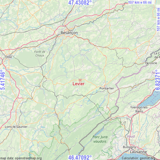
Levier GPS coordinates[2]
46° 57' 10.872" North, 6° 7' 14.124" East
| Map corner | latitude | longitude |
|---|---|---|
| Upper-left | 47.43082°, | 5.41746° |
| Center: | 46.95302°, | 6.12059° |
| Lower-right: | 46.47092°, | 6.82371° |
| Map W x H: | 106.7×106.7 km | = 66.3×66.3mi |
| max Lat: | 51.07786° ⇑55.7% North |
| Levier: | 46.95302° |
| min Lat: | ⇓44.3% South 41.3874° |
| min Long | Levier | max Long |
| -5.08615° | 6.12059° | 9.52242° |
| W 88.4%⇐ | ⇒11.6% E |
Elevation
Elevation of Levier is 716 m = 2349 ft, and this is 522.3 m = 1714 ft above average elevation for this country.
| Max E: |
2333 m = 7654 ft | 3.2% |
| Levier | 716 m 2349 ft | |
| Avg. | 193.7 m = 635 ft | |
Min E: |
-1 m = -3 ft | 96.8% |
See also: France elevation on elevation.city.
Geographical zone
Levier is located in North temperate zone (between Tropic of Cancer and the Arctic Circle). Distance of this North polar circle is 2180.5 km =1354.9 mi to North.| Distance of | km | miles | from Levier |
|---|---|---|---|
| North Pole | 4786.4 | 2974.1 | to North |
| Arctic Circle | 2180.5 | 1354.9 | to North |
| Tropic Cancer | 2614.8 | 1624.8 | to South |
| Equator | 5220.7 | 3244 | to South |


Nearby cities:
15 places around Levier: (largest is in red/bold)
• Amancey
10.1 km =6.3 mi,  338°
338°
• Bians-les-Usiers
11.8 km =7.3 mi,  83°
83°
• Chaffois
12.4 km =7.7 mi,  111°
111°
• Dommartin
14.6 km =9.1 mi,  103°
103°
• Doubs
17.7 km =11 mi, 99°
• Frasne
11.1 km =6.9 mi,  164°
164°
• Goux-les-Usiers
12.1 km =7.5 mi, 79°
• Granges-Narboz
17 km =10.6 mi,  117°
117°
• Houtaud
15 km =9.3 mi, 105°
• La Rivière-Drugeon
12 km =7.5 mi,  141°
141°
• Mignovillard
18 km =11.2 mi,  178°
178°
• Ornans
17.3 km =10.7 mi,  5°
5°
• Sombacour
10.4 km =6.5 mi,  90°
90°
• Vuillafans
14.4 km =8.9 mi,  30°
30°
• Vuillecin
15.4 km =9.6 mi, 95°
Sources, notices
• [Note1] Compared only with cities in France existing in our database
• [Src1] Map data: © OpenStreetMap contributors (CC-BY-SA)
• [Src2] Other city data from geonames.org with taken over terms of usage.
• [Src3] Geographical zone / Annual Mean Temperature by Robert A. Rohde @ Wikipedia
