Les Verchers-sur-Layon geodata
Les Verchers-sur-Layon (Pays de la Loire) is a populated place; located in France in Europe/Paris (GMT+2) time zone. With population of 868 people, there are 9914 cities with bigger population in this country. Compared to other cities in France, 53.6% of cities are located further ↑North; 80.8% of cities are located further →East and 79.8% of cities have higher elevation than Les Verchers-sur-Layon. Note1
Administrative division(s):
- Level 1: Pays de la Loire
- Level 2: Département de Maine-et-Loire
- Level 3: Arrondissement de Saumur
- Level 4: Doué-en-Anjou
Current local time in Les Verchers-sur-Layon:
09:59 AM, SaturdayDifference from your time zone: hours


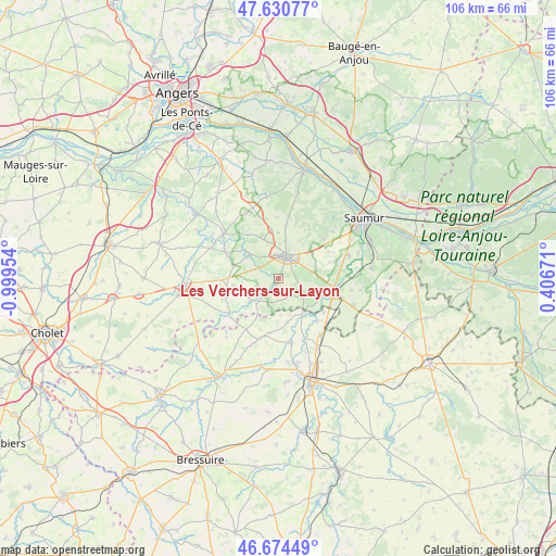
Les Verchers-sur-Layon GPS coordinates[2]
47° 9' 17.208" North, 0° 17' 47.076" West
| Map corner | latitude | longitude |
|---|---|---|
| Upper-left | 47.63077°, | -0.99954° |
| Center: | 47.15478°, | -0.29641° |
| Lower-right: | 46.67449°, | 0.40671° |
| Map W x H: | 106.3×106.3 km | = 66.1×66.1mi |
| max Lat: | 51.07786° ⇑53.6% North |
| Les Verchers-sur-Layon: | 47.15478° |
| min Lat: | ⇓46.4% South 41.3874° |
| min Long | Les Verchers-su | max Long |
| -5.08615° | -0.29641° | 9.52242° |
| W 19.2%⇐ | ⇒80.8% E |
Elevation
Elevation of Les Verchers-sur-Layon is 55 m = 180 ft, and this is 138.7 m = 455 ft below average elevation for this country.
| Max E: |
2333 m = 7654 ft | 79.8% |
| Avg. | 193.7 m = 635 ft | |
| Les Verchers-sur-Layon | 55 m = 180 ft | |
Min E: |
-1 m = -3 ft | 20.2% |
See also: France elevation on elevation.city.
Geographical zone
Les Verchers-sur-Layon is located in North temperate zone (between Tropic of Cancer and the Arctic Circle). Distance of this North polar circle is 2158.1 km =1341 mi to North.| Distance of | km | miles | from Les Verchers-sur-Layon |
|---|---|---|---|
| North Pole | 4763.9 | 2960.1 | to North |
| Arctic Circle | 2158.1 | 1341 | to North |
| Tropic Cancer | 2637.2 | 1638.7 | to South |
| Equator | 5243.1 | 3257.9 | to South |


Nearby cities:
15 places around Les Verchers-sur-Layon: (largest is in red/bold)
• Ambillou-Château
12.5 km =7.8 mi,  343°
343°
• Bouillé-Loretz
8.6 km =5.3 mi,  167°
167°
• Cersay
12.9 km =8 mi,  199°
199°
• Concourson-sur-Layon
4 km =2.5 mi,  303°
303°
• Doué-la-Fontaine
4.6 km =2.9 mi,  20°
20°
• Le Puy-Notre-Dame
5.6 km =3.5 mi,  125°
125°
• Les Ulmes
11.5 km =7.1 mi,  50°
50°
• Louresse-Rochemenier
9.4 km =5.8 mi,  351°
351°
• Montreuil-Bellay
11.2 km =7 mi,  103°
103°
• Nueil-sur-Layon
6.6 km =4.1 mi,  232°
232°
• Saint-Georges-sur-Layon
7.2 km =4.5 mi,  311°
311°
• Saint-Jean
12.1 km =7.5 mi,  326°
326°
• Saint-Martin-de-Sanzay
11 km =6.8 mi,  137°
137°
• Tigné
11.1 km =6.9 mi, 297°
• Vaudelnay
7 km =4.3 mi,  105°
105°
Sources, notices
• [Note1] Compared only with cities in France existing in our database
• [Src1] Map data: © OpenStreetMap contributors (CC-BY-SA)
• [Src2] Other city data from geonames.org with taken over terms of usage.
• [Src3] Geographical zone / Annual Mean Temperature by Robert A. Rohde @ Wikipedia
