Louresse-Rochemenier geodata
Louresse-Rochemenier (Pays de la Loire) is a populated place; located in France in Europe/Paris (GMT+2) time zone. With population of 651 people, there are 12511 cities with bigger population in this country. Compared to other cities in France, 52.5% of cities are located further ↑North; 81% of cities are located further →East and 71.4% of cities have higher elevation than Louresse-Rochemenier. Note1
Administrative division(s):
- Level 1: Pays de la Loire
- Level 2: Département de Maine-et-Loire
- Level 3: Arrondissement de Saumur
- Level 4: Louresse-Rochemenier


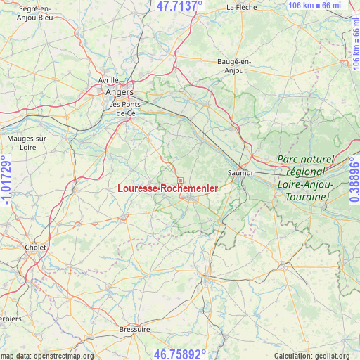
Louresse-Rochemenier GPS coordinates[2]
47° 14' 18.456" North, 0° 18' 51.012" West
| Map corner | latitude | longitude |
|---|---|---|
| Upper-left | 47.7137°, | -1.01729° |
| Center: | 47.23846°, | -0.31417° |
| Lower-right: | 46.75892°, | 0.38896° |
| Map W x H: | 106.2×106.2 km | = 66×66mi |
| max Lat: | 51.07786° ⇑52.5% North |
| Louresse-Rochemenier: | 47.23846° |
| min Lat: | ⇓47.5% South 41.3874° |
| min Long | Louresse-Rochem | max Long |
| -5.08615° | -0.31417° | 9.52242° |
| W 19%⇐ | ⇒81% E |
Elevation
Elevation of Louresse-Rochemenier is 75 m = 246 ft, and this is 118.7 m = 389 ft below average elevation for this country.
| Max E: |
2333 m = 7654 ft | 71.4% |
| Avg. | 193.7 m = 635 ft | |
| Louresse-Rochemenier | 75 m = 246 ft | |
Min E: |
-1 m = -3 ft | 28.6% |
See also: France elevation on elevation.city.
Geographical zone
Louresse-Rochemenier is located in North temperate zone (between Tropic of Cancer and the Arctic Circle). Distance of this North polar circle is 2148.7 km =1335.1 mi to North.| Distance of | km | miles | from Louresse-Rochemenier |
|---|---|---|---|
| North Pole | 4754.6 | 2954.4 | to North |
| Arctic Circle | 2148.7 | 1335.1 | to North |
| Tropic Cancer | 2646.5 | 1644.5 | to South |
| Equator | 5252.4 | 3263.7 | to South |


Nearby cities:
15 places around Louresse-Rochemenier: (largest is in red/bold)
• Ambillou-Château
3.5 km =2.2 mi,  319°
319°
• Chavagnes
11.2 km =7 mi,  288°
288°
• Chemellier
11.9 km =7.4 mi,  343°
343°
• Concourson-sur-Layon
7.4 km =4.6 mi,  195°
195°
• Doué-la-Fontaine
5.8 km =3.6 mi,  149°
149°
• Gennes
12.9 km =8 mi,  28°
28°
• Les Alleuds
11.4 km =7.1 mi, 321°
• Les Ulmes
10.4 km =6.5 mi,  101°
101°
• Les Verchers-sur-Layon
9.4 km =5.8 mi,  171°
171°
• Martigné-Briand
8.7 km =5.4 mi,  266°
266°
• Rou-Marson
12 km =7.5 mi,  91°
91°
• Saint-Georges-des-Sept-Voies
12.6 km =7.8 mi,  10°
10°
• Saint-Georges-sur-Layon
6.1 km =3.8 mi,  221°
221°
• Saint-Jean
5.3 km =3.3 mi,  278°
278°
• Tigné
9.6 km =6 mi,  243°
243°
Sources, notices
• [Note1] Compared only with cities in France existing in our database
• [Src1] Map data: © OpenStreetMap contributors (CC-BY-SA)
• [Src2] Other city data from geonames.org with taken over terms of usage.
• [Src3] Geographical zone / Annual Mean Temperature by Robert A. Rohde @ Wikipedia
