Doué-la-Fontaine geodata
Doué-la-Fontaine (Pays de la Loire) is a populated place; located in France in Europe/Paris (GMT+2) time zone. With population of 8,089 people, there are 1199 cities with bigger population in this country. Compared to other cities in France, 53.1% of cities are located further ↑North; 80.6% of cities are located further →East and 70.5% of cities have higher elevation than Doué-la-Fontaine. Note1
Administrative division(s):
- Level 1: Pays de la Loire
- Level 2: Département de Maine-et-Loire
- Level 3: Arrondissement de Saumur
- Level 4: Doué-en-Anjou


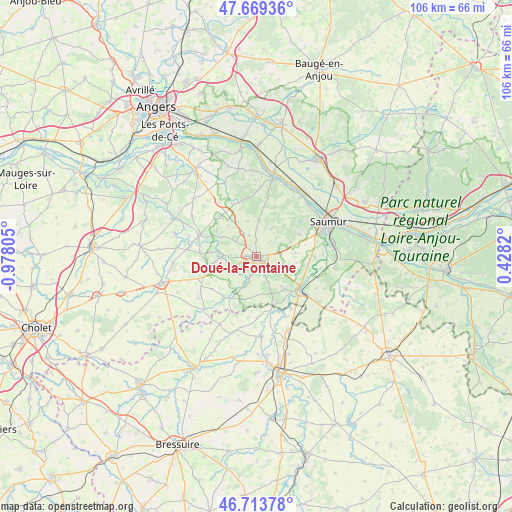
Doué-la-Fontaine GPS coordinates[2]
47° 11' 37.392" North, 0° 16' 29.712" West
| Map corner | latitude | longitude |
|---|---|---|
| Upper-left | 47.66936°, | -0.97805° |
| Center: | 47.19372°, | -0.27492° |
| Lower-right: | 46.71378°, | 0.4282° |
| Map W x H: | 106.3×106.2 km | = 66.1×66mi |
| max Lat: | 51.07786° ⇑53.1% North |
| Doué-la-Fontaine: | 47.19372° |
| min Lat: | ⇓46.9% South 41.3874° |
| min Long | Doué-la-Fontai | max Long |
| -5.08615° | -0.27492° | 9.52242° |
| W 19.4%⇐ | ⇒80.6% E |
Elevation
Elevation of Doué-la-Fontaine is 77 m = 253 ft, and this is 116.7 m = 383 ft below average elevation for this country.
| Max E: |
2333 m = 7654 ft | 70.5% |
| Avg. | 193.7 m = 635 ft | |
| Doué-la-Fontaine | 77 m = 253 ft | |
Min E: |
-1 m = -3 ft | 29.5% |
See also: France elevation on elevation.city.
Geographical zone
Doué-la-Fontaine is located in North temperate zone (between Tropic of Cancer and the Arctic Circle). Distance of this North polar circle is 2153.7 km =1338.2 mi to North.| Distance of | km | miles | from Doué-la-Fontaine |
|---|---|---|---|
| North Pole | 4759.6 | 2957.5 | to North |
| Arctic Circle | 2153.7 | 1338.2 | to North |
| Tropic Cancer | 2641.5 | 1641.4 | to South |
| Equator | 5247.4 | 3260.6 | to South |


Nearby cities:
15 places around Doué-la-Fontaine: (largest is in red/bold)
• Ambillou-Château
9.3 km =5.8 mi,  325°
325°
• Concourson-sur-Layon
5.4 km =3.4 mi,  246°
246°
• Le Coudray-Macouard
12 km =7.5 mi,  88°
88°
• Le Puy-Notre-Dame
8.1 km =5 mi,  158°
158°
• Les Ulmes
7.8 km =4.8 mi,  68°
68°
• Les Verchers-sur-Layon
4.6 km =2.9 mi,  200°
200°
• Louresse-Rochemenier
5.8 km =3.6 mi, 329°
• Martigné-Briand
12.5 km =7.8 mi,  290°
290°
• Montreuil-Bellay
11.6 km =7.2 mi,  126°
126°
• Nueil-sur-Layon
10.9 km =6.8 mi,  219°
219°
• Rou-Marson
10.1 km =6.3 mi,  62°
62°
• Saint-Georges-sur-Layon
7 km =4.3 mi,  273°
273°
• Saint-Jean
10.1 km =6.3 mi,  304°
304°
• Tigné
11.6 km =7.2 mi, 273°
• Vaudelnay
8 km =5 mi,  140°
140°
Sources, notices
• [Note1] Compared only with cities in France existing in our database
• [Src1] Map data: © OpenStreetMap contributors (CC-BY-SA)
• [Src2] Other city data from geonames.org with taken over terms of usage.
• [Src3] Geographical zone / Annual Mean Temperature by Robert A. Rohde @ Wikipedia
