Le Plessis-Robinson geodata
Le Plessis-Robinson (Île-de-France) is a populated place; located in France in Europe/Paris (GMT+2) time zone. With population of 22,510 people, there are 400 cities with bigger population in this country. Compared to other cities in France, 75.3% of cities are located further ↓South; 53.2% of cities are located further →East and 57.4% of cities have lower elevation than Le Plessis-Robinson. Note1
Administrative division(s):
- Level 1: Île-de-France
- Level 2: Hauts-de-Seine
- Level 3: Arrondissement d'Antony
- Level 4: Le Plessis-Robinson


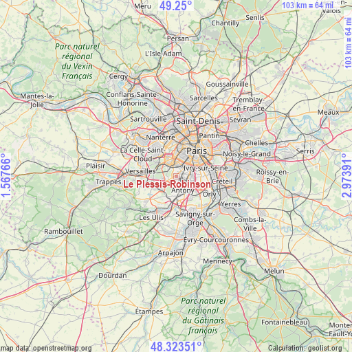
Le Plessis-Robinson GPS coordinates[2]
48° 47' 20.004" North, 2° 16' 14.808" East
| Map corner | latitude | longitude |
|---|---|---|
| Upper-left | 49.25°, | 1.56766° |
| Center: | 48.78889°, | 2.27078° |
| Lower-right: | 48.32351°, | 2.97391° |
| Map W x H: | 103×103 km | = 64×64mi |
| max Lat: | 51.07786° ⇑24.7% North |
| Le Plessis-Robinson: | 48.78889° |
| min Lat: | ⇓75.3% South 41.3874° |
| min Long | Le Plessis-Robi | max Long |
| -5.08615° | 2.27078° | 9.52242° |
| W 46.8%⇐ | ⇒53.2% E |
Elevation
Elevation of Le Plessis-Robinson is 159 m = 522 ft, and this is 34.7 m = 114 ft below average elevation for this country.
| Max E: |
2333 m = 7654 ft | 42.6% |
| Avg. | 193.7 m = 635 ft | |
| Le Plessis-Robinson | 159 m = 522 ft | |
Min E: |
-1 m = -3 ft | 57.4% |
See also: France elevation on elevation.city.
Geographical zone
Le Plessis-Robinson is located in North temperate zone (between Tropic of Cancer and the Arctic Circle). Distance of this North polar circle is 1976.4 km =1228.1 mi to North.| Distance of | km | miles | from Le Plessis-Robinson |
|---|---|---|---|
| North Pole | 4582.2 | 2847.2 | to North |
| Arctic Circle | 1976.4 | 1228.1 | to North |
| Tropic Cancer | 2818.9 | 1751.6 | to South |
| Equator | 5424.8 | 3370.8 | to South |


Nearby cities:
15 places around Le Plessis-Robinson: (largest is in red/bold)
• Antony
4.4 km =2.7 mi,  154°
154°
• Arcueil
4.7 km =2.9 mi,  74°
74°
• Bagneux
2.8 km =1.7 mi, 74°
• Bourg-la-Reine
3.6 km =2.2 mi,  107°
107°
• Châtenay-Malabry
2.7 km =1.7 mi,  186°
186°
• Châtillon
2.2 km =1.4 mi,  47°
47°
• Clamart
1.6 km =1 mi,  349°
349°
• Fontenay-aux-Roses
1.7 km =1.1 mi, 73°
• Issy-les-Moulineaux
3.6 km =2.2 mi,  7°
7°
• L'Haÿ-les-Roses
4.6 km =2.9 mi,  97°
97°
• Malakoff
4.1 km =2.5 mi,  31°
31°
• Meudon
3.8 km =2.4 mi,  316°
316°
• Montrouge
4.4 km =2.7 mi, 46°
• Sceaux
2 km =1.2 mi,  134°
134°
• Vanves
4.1 km =2.5 mi,  20°
20°
Sources, notices
• [Note1] Compared only with cities in France existing in our database
• [Src1] Map data: © OpenStreetMap contributors (CC-BY-SA)
• [Src2] Other city data from geonames.org with taken over terms of usage.
• [Src3] Geographical zone / Annual Mean Temperature by Robert A. Rohde @ Wikipedia
