Bagneux geodata
Bagneux (Île-de-France) is a populated place; located in France in Europe/Paris (GMT+2) time zone. With population of 38,900 people, there are 191 cities with bigger population in this country. Compared to other cities in France, 75.5% of cities are located further ↓South; 52.6% of cities are located further →East and 56.9% of cities have higher elevation than Bagneux. Note1
Administrative division(s):
- Level 1: Île-de-France
- Level 2: Hauts-de-Seine
- Level 3: Arrondissement d'Antony
- Level 4: Bagneux


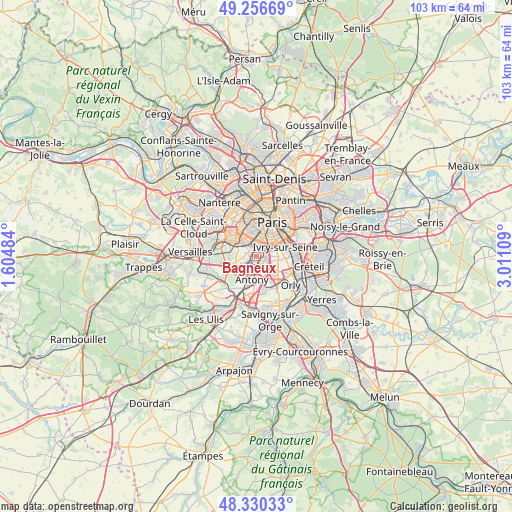
Bagneux GPS coordinates[2]
48° 47' 44.34" North, 2° 18' 28.656" East
| Map corner | latitude | longitude |
|---|---|---|
| Upper-left | 49.25669°, | 1.60484° |
| Center: | 48.79565°, | 2.30796° |
| Lower-right: | 48.33033°, | 3.01109° |
| Map W x H: | 103×103 km | = 64×64mi |
| max Lat: | 51.07786° ⇑24.5% North |
| Bagneux: | 48.79565° |
| min Lat: | ⇓75.5% South 41.3874° |
| min Long | Bagneux | max Long |
| -5.08615° | 2.30796° | 9.52242° |
| W 47.4%⇐ | ⇒52.6% E |
Elevation
Elevation of Bagneux is 111 m = 364 ft, and this is 82.7 m = 271 ft below average elevation for this country.
| Max E: |
2333 m = 7654 ft | 56.9% |
| Avg. | 193.7 m = 635 ft | |
| Bagneux | 111 m = 364 ft | |
Min E: |
-1 m = -3 ft | 43.1% |
See also: France elevation on elevation.city.
Geographical zone
Bagneux is located in North temperate zone (between Tropic of Cancer and the Arctic Circle). Distance of this North polar circle is 1975.6 km =1227.6 mi to North.| Distance of | km | miles | from Bagneux |
|---|---|---|---|
| North Pole | 4581.5 | 2846.8 | to North |
| Arctic Circle | 1975.6 | 1227.6 | to North |
| Tropic Cancer | 2819.6 | 1752 | to South |
| Equator | 5425.6 | 3371.3 | to South |


Nearby cities:
15 places around Bagneux: (largest is in red/bold)
• Arcueil
1.9 km =1.2 mi,  75°
75°
• Bourg-la-Reine
2 km =1.2 mi,  158°
158°
• Cachan
2.1 km =1.3 mi,  87°
87°
• Châtillon
1.3 km =0.8 mi,  305°
305°
• Clamart
3.1 km =1.9 mi,  285°
285°
• Fontenay-aux-Roses
1.1 km =0.7 mi,  256°
256°
• Gentilly
3.1 km =1.9 mi,  52°
52°
• Issy-les-Moulineaux
3.6 km =2.2 mi,  321°
321°
• L'Haÿ-les-Roses
2.3 km =1.4 mi,  126°
126°
• Le Plessis-Robinson
2.8 km =1.7 mi,  254°
254°
• Malakoff
2.8 km =1.7 mi,  347°
347°
• Montrouge
2.3 km =1.4 mi,  10°
10°
• Sceaux
2.5 km =1.6 mi,  211°
211°
• Vanves
3.4 km =2.1 mi,  337°
337°
• Villejuif
3.8 km =2.4 mi, 92°
Sources, notices
• [Note1] Compared only with cities in France existing in our database
• [Src1] Map data: © OpenStreetMap contributors (CC-BY-SA)
• [Src2] Other city data from geonames.org with taken over terms of usage.
• [Src3] Geographical zone / Annual Mean Temperature by Robert A. Rohde @ Wikipedia
