Antony geodata
Antony (Île-de-France) is a seat of a third-order administrative division; located in France in Europe/Paris (GMT+2) time zone. With population of 59,845 people, there are 84 cities with bigger population in this country. Compared to other cities in France, 74.4% of cities are located further ↓South; 52.8% of cities are located further →East and 81.1% of cities have higher elevation than Antony. Note1
Administrative division(s):
- Level 1: Île-de-France
- Level 2: Hauts-de-Seine
- Level 3: Arrondissement d'Antony
- Level 4: Antony


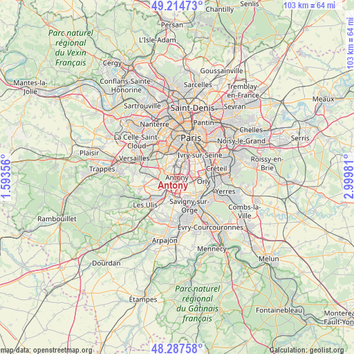
Antony GPS coordinates[2]
48° 45' 11.844" North, 2° 17' 48.048" East
| Map corner | latitude | longitude |
|---|---|---|
| Upper-left | 49.21473°, | 1.59356° |
| Center: | 48.75329°, | 2.29668° |
| Lower-right: | 48.28758°, | 2.99981° |
| Map W x H: | 103.1×103.1 km | = 64.1×64.1mi |
| max Lat: | 51.07786° ⇑25.6% North |
| Antony: | 48.75329° |
| min Lat: | ⇓74.4% South 41.3874° |
| min Long | Antony | max Long |
| -5.08615° | 2.29668° | 9.52242° |
| W 47.2%⇐ | ⇒52.8% E |
Elevation
Elevation of Antony is 52 m = 171 ft, and this is 141.7 m = 465 ft below average elevation for this country.
| Max E: |
2333 m = 7654 ft | 81.1% |
| Avg. | 193.7 m = 635 ft | |
| Antony | 52 m = 171 ft | |
Min E: |
-1 m = -3 ft | 18.9% |
See also: Antony elevation on elevation.city.
Geographical zone
Antony is located in North temperate zone (between Tropic of Cancer and the Arctic Circle). Distance of this North polar circle is 1980.3 km =1230.5 mi to North.| Distance of | km | miles | from Antony |
|---|---|---|---|
| North Pole | 4586.2 | 2849.7 | to North |
| Arctic Circle | 1980.3 | 1230.5 | to North |
| Tropic Cancer | 2814.9 | 1749.1 | to South |
| Equator | 5420.9 | 3368.4 | to South |


Nearby cities:
15 places around Antony: (largest is in red/bold)
• Bagneux
4.8 km =3 mi,  9°
9°
• Bourg-la-Reine
3.2 km =2 mi,  28°
28°
• Champlan
5.2 km =3.2 mi,  193°
193°
• Chevilly-Larue
4.1 km =2.5 mi,  72°
72°
• Chilly-Mazarin
4.5 km =2.8 mi,  161°
161°
• Châtenay-Malabry
2.6 km =1.6 mi,  300°
300°
• Fontenay-aux-Roses
4.5 km =2.8 mi,  356°
356°
• Fresnes
1.9 km =1.2 mi,  81°
81°
• L'Haÿ-les-Roses
4.3 km =2.7 mi,  38°
38°
• Le Plessis-Robinson
4.4 km =2.7 mi,  334°
334°
• Massy
3.1 km =1.9 mi,  198°
198°
• Rungis
4.2 km =2.6 mi,  101°
101°
• Sceaux
2.6 km =1.6 mi,  349°
349°
• Verrières-le-Buisson
2.3 km =1.4 mi,  248°
248°
• Wissous
2.9 km =1.8 mi,  138°
138°
Sources, notices
• [Note1] Compared only with cities in France existing in our database
• [Src1] Map data: © OpenStreetMap contributors (CC-BY-SA)
• [Src2] Other city data from geonames.org with taken over terms of usage.
• [Src3] Geographical zone / Annual Mean Temperature by Robert A. Rohde @ Wikipedia
