Le Plessis-Pâté geodata
Le Plessis-Pâté (Île-de-France) is a populated place; located in France in Europe/Paris (GMT+2) time zone. With population of 4,031 people, there are 2435 cities with bigger population in this country. Compared to other cities in France, 71.1% of cities are located further ↓South; 52.3% of cities are located further →East and 70.1% of cities have higher elevation than Le Plessis-Pâté. Note1
Administrative division(s):
- Level 1: Île-de-France
- Level 2: Département de l'Essonne
- Level 3: Arrondissement de Palaiseau
- Level 4: Le Plessis-Pâté


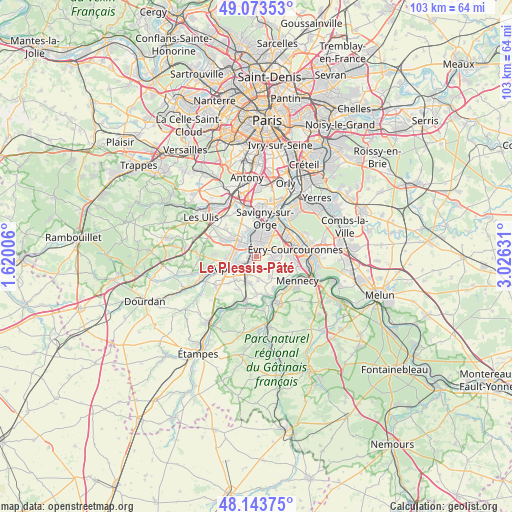
Le Plessis-Pâté GPS coordinates[2]
48° 36' 38.808" North, 2° 19' 23.448" East
| Map corner | latitude | longitude |
|---|---|---|
| Upper-left | 49.07353°, | 1.62006° |
| Center: | 48.61078°, | 2.32318° |
| Lower-right: | 48.14375°, | 3.02631° |
| Map W x H: | 103.4×103.4 km | = 64.2×64.2mi |
| max Lat: | 51.07786° ⇑28.9% North |
| Le Plessis-Pâté: | 48.61078° |
| min Lat: | ⇓71.1% South 41.3874° |
| min Long | Le Plessis-Pât | max Long |
| -5.08615° | 2.32318° | 9.52242° |
| W 47.7%⇐ | ⇒52.3% E |
Elevation
Elevation of Le Plessis-Pâté is 78 m = 256 ft, and this is 115.7 m = 380 ft below average elevation for this country.
| Max E: |
2333 m = 7654 ft | 70.1% |
| Avg. | 193.7 m = 635 ft | |
| Le Plessis-Pâté | 78 m = 256 ft | |
Min E: |
-1 m = -3 ft | 29.9% |
See also: France elevation on elevation.city.
Geographical zone
Le Plessis-Pâté is located in North temperate zone (between Tropic of Cancer and the Arctic Circle). Distance of this North polar circle is 1996.2 km =1240.4 mi to North.| Distance of | km | miles | from Le Plessis-Pâté |
|---|---|---|---|
| North Pole | 4602 | 2859.5 | to North |
| Arctic Circle | 1996.2 | 1240.4 | to North |
| Tropic Cancer | 2799.1 | 1739.3 | to South |
| Equator | 5405 | 3358.5 | to South |


Nearby cities:
15 places around Le Plessis-Pâté: (largest is in red/bold)
• Bondoufle
4 km =2.5 mi,  86°
86°
• Brétigny-sur-Orge
1.3 km =0.8 mi,  272°
272°
• Fleury-Mérogis
4.2 km =2.6 mi,  45°
45°
• La Norville
5.5 km =3.4 mi,  235°
235°
• Leudeville
5 km =3.1 mi,  176°
176°
• Leuville-sur-Orge
4.2 km =2.6 mi,  279°
279°
• Linas
5 km =3.1 mi,  296°
296°
• Longpont-sur-Orge
4.1 km =2.5 mi,  326°
326°
• Marolles-en-Hurepoix
5.7 km =3.5 mi,  198°
198°
• Montlhéry
4.8 km =3 mi,  312°
312°
• Saint-Germain-lès-Arpajon
4.5 km =2.8 mi,  250°
250°
• Saint-Michel-sur-Orge
2.9 km =1.8 mi,  337°
337°
• Sainte-Geneviève-des-Bois
4 km =2.5 mi,  356°
356°
• Vert-le-Grand
5 km =3.1 mi,  149°
149°
• Villiers-sur-Orge
5.7 km =3.5 mi, 342°
Sources, notices
• [Note1] Compared only with cities in France existing in our database
• [Src1] Map data: © OpenStreetMap contributors (CC-BY-SA)
• [Src2] Other city data from geonames.org with taken over terms of usage.
• [Src3] Geographical zone / Annual Mean Temperature by Robert A. Rohde @ Wikipedia
