Marolles-en-Hurepoix geodata
Marolles-en-Hurepoix (Île-de-France) is a populated place; located in France in Europe/Paris (GMT+2) time zone. With population of 4,921 people, there are 2011 cities with bigger population in this country. Compared to other cities in France, 69.8% of cities are located further ↓South; 52.8% of cities are located further →East and 67% of cities have higher elevation than Marolles-en-Hurepoix. Note1
Administrative division(s):
- Level 1: Île-de-France
- Level 2: Département de l'Essonne
- Level 3: Arrondissement de Palaiseau
- Level 4: Marolles-en-Hurepoix


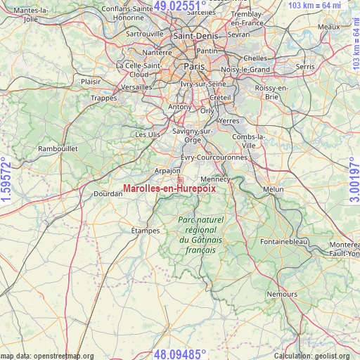
Marolles-en-Hurepoix GPS coordinates[2]
48° 33' 44.352" North, 2° 17' 55.86" East
| Map corner | latitude | longitude |
|---|---|---|
| Upper-left | 49.02551°, | 1.59572° |
| Center: | 48.56232°, | 2.29885° |
| Lower-right: | 48.09485°, | 3.00197° |
| Map W x H: | 103.5×103.5 km | = 64.3×64.3mi |
| max Lat: | 51.07786° ⇑30.2% North |
| Marolles-en-Hurepoix: | 48.56232° |
| min Lat: | ⇓69.8% South 41.3874° |
| min Long | Marolles-en-Hur | max Long |
| -5.08615° | 2.29885° | 9.52242° |
| W 47.2%⇐ | ⇒52.8% E |
Elevation
Elevation of Marolles-en-Hurepoix is 85 m = 279 ft, and this is 108.7 m = 357 ft below average elevation for this country.
| Max E: |
2333 m = 7654 ft | 67% |
| Avg. | 193.7 m = 635 ft | |
| Marolles-en-Hurepoix | 85 m = 279 ft | |
Min E: |
-1 m = -3 ft | 33% |
See also: France elevation on elevation.city.
Geographical zone
Marolles-en-Hurepoix is located in North temperate zone (between Tropic of Cancer and the Arctic Circle). Distance of this North polar circle is 2001.6 km =1243.7 mi to North.| Distance of | km | miles | from Marolles-en-Hurepoix |
|---|---|---|---|
| North Pole | 4607.4 | 2862.9 | to North |
| Arctic Circle | 2001.6 | 1243.7 | to North |
| Tropic Cancer | 2793.7 | 1735.9 | to South |
| Equator | 5399.6 | 3355.2 | to South |


Nearby cities:
15 places around Marolles-en-Hurepoix: (largest is in red/bold)
• Arpajon
4.8 km =3 mi,  307°
307°
• Avrainville
3.9 km =2.4 mi,  270°
270°
• Bouray-sur-Juine
4.7 km =2.9 mi,  178°
178°
• Brétigny-sur-Orge
5.5 km =3.4 mi,  5°
5°
• Cheptainville
2.1 km =1.3 mi,  232°
232°
• Guibeville
2.2 km =1.4 mi,  294°
294°
• Janville-sur-Juine
5.8 km =3.6 mi,  200°
200°
• La Norville
3.5 km =2.2 mi, 309°
• Lardy
5.2 km =3.2 mi, 200°
• Le Plessis-Pâté
5.7 km =3.5 mi,  18°
18°
• Leudeville
2.1 km =1.3 mi,  79°
79°
• Saint-Germain-lès-Arpajon
4.6 km =2.9 mi,  327°
327°
• Saint-Vrain
3.3 km =2.1 mi,  130°
130°
• Vert-le-Grand
4.5 km =2.8 mi, 76°
• Vert-le-Petit
5 km =3.1 mi,  103°
103°
Sources, notices
• [Note1] Compared only with cities in France existing in our database
• [Src1] Map data: © OpenStreetMap contributors (CC-BY-SA)
• [Src2] Other city data from geonames.org with taken over terms of usage.
• [Src3] Geographical zone / Annual Mean Temperature by Robert A. Rohde @ Wikipedia
