Crevin geodata
Crevin (Brittany) is a populated place; located in France in Europe/Paris (GMT+2) time zone. With population of 1,872 people, there are 5085 cities with bigger population in this country. Compared to other cities in France, 58.1% of cities are located further ↓South; 93.3% of cities are located further →East and 71% of cities have higher elevation than Crevin. Note1
Administrative division(s):
- Level 1: Brittany
- Level 2: Département d'Ille-et-Vilaine
- Level 3: Arrondissement de Redon
- Level 4: Crevin


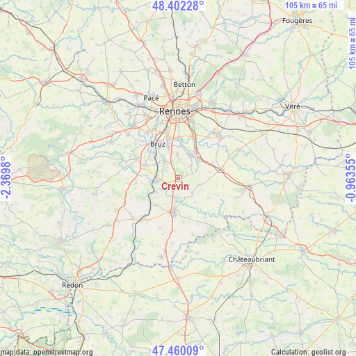
Crevin GPS coordinates[2]
47° 55' 59.988" North, 1° 40' 0.012" West
| Map corner | latitude | longitude |
|---|---|---|
| Upper-left | 48.40228°, | -2.3698° |
| Center: | 47.93333°, | -1.66667° |
| Lower-right: | 47.46009°, | -0.96355° |
| Map W x H: | 104.8×104.8 km | = 65.1×65.1mi |
| max Lat: | 51.07786° ⇑41.9% North |
| Crevin: | 47.93333° |
| min Lat: | ⇓58.1% South 41.3874° |
| min Long | Crevin | max Long |
| -5.08615° | -1.66667° | 9.52242° |
| W 6.7%⇐ | ⇒93.3% E |
Elevation
Elevation of Crevin is 76 m = 249 ft, and this is 117.7 m = 386 ft below average elevation for this country.
| Max E: |
2333 m = 7654 ft | 71% |
| Avg. | 193.7 m = 635 ft | |
| Crevin | 76 m = 249 ft | |
Min E: |
-1 m = -3 ft | 29% |
See also: France elevation on elevation.city.
Geographical zone
Crevin is located in North temperate zone (between Tropic of Cancer and the Arctic Circle). Distance of this North polar circle is 2071.5 km =1287.2 mi to North.| Distance of | km | miles | from Crevin |
|---|---|---|---|
| North Pole | 4677.4 | 2906.4 | to North |
| Arctic Circle | 2071.5 | 1287.2 | to North |
| Tropic Cancer | 2723.8 | 1692.5 | to South |
| Equator | 5329.7 | 3311.7 | to South |


Nearby cities:
15 places around Crevin: (largest is in red/bold)
• Bourg-des-Comptes
5.9 km =3.7 mi,  265°
265°
• Bourgbarré
7.9 km =4.9 mi,  29°
29°
• Brie
9.9 km =6.2 mi,  78°
78°
• Chanteloup
5.3 km =3.3 mi,  46°
46°
• Corps-Nuds
8 km =5 mi, 50°
• Laillé
6.3 km =3.9 mi,  323°
323°
• Le Petit-Fougeray
4.4 km =2.7 mi,  97°
97°
• Le Sel-de-Bretagne
5.3 km =3.3 mi,  134°
134°
• Orgères
7.3 km =4.5 mi,  359°
359°
• Pancé
5.8 km =3.6 mi,  174°
174°
• Pléchâtel
7.5 km =4.7 mi,  235°
235°
• Poligné
5.3 km =3.3 mi,  195°
195°
• Saint-Erblon
9.6 km =6 mi,  6°
6°
• Saint-Senoux
9.6 km =6 mi,  251°
251°
• Saulnières
6.4 km =4 mi,  108°
108°
Sources, notices
• [Note1] Compared only with cities in France existing in our database
• [Src1] Map data: © OpenStreetMap contributors (CC-BY-SA)
• [Src2] Other city data from geonames.org with taken over terms of usage.
• [Src3] Geographical zone / Annual Mean Temperature by Robert A. Rohde @ Wikipedia
