el Pertús geodata
el Pertús (Occitanie) is a populated place; located in France in Europe/Paris (GMT+2) time zone. With population of 571 people, there are 13815 cities with bigger population in this country. Compared to other cities in France, 99.6% of cities are located further ↑North; 55.8% of cities are located further ←West and 80.2% of cities have lower elevation than el Pertús. Note1
Administrative division(s):
- Level 1: Occitanie
- Level 2: Département des Pyrénées-Orientales
- Level 3: Arrondissement de Céret
- Level 4: Le Perthus


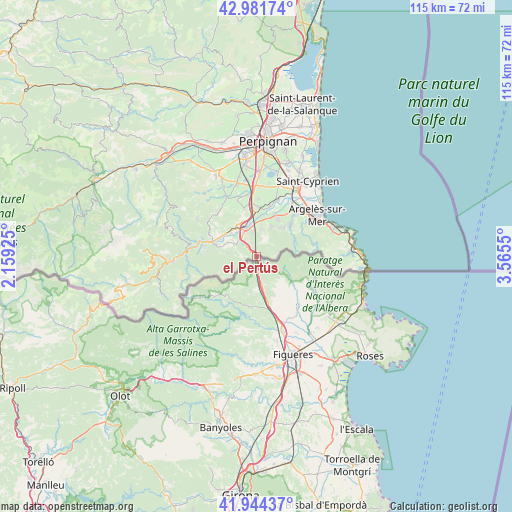
el Pertús GPS coordinates[2]
42° 27' 54.72" North, 2° 51' 44.532" East
| Map corner | latitude | longitude |
|---|---|---|
| Upper-left | 42.98174°, | 2.15925° |
| Center: | 42.4652°, | 2.86237° |
| Lower-right: | 41.94437°, | 3.5655° |
| Map W x H: | 115.3×115.3 km | = 71.6×71.6mi |
| max Lat: | 51.07786° ⇑99.6% North |
| el Pertús: | 42.4652° |
| min Lat: | ⇓0.4% South 41.3874° |
| min Long | el Pertús | max Long |
| -5.08615° | 2.86237° | 9.52242° |
| W 55.8%⇐ | ⇒44.2% E |
Elevation
Elevation of el Pertús is 292 m = 958 ft, and this is 98.3 m = 323 ft above average elevation for this country.
| Max E: |
2333 m = 7654 ft | 19.8% |
| el Pertús | 292 m 958 ft | |
| Avg. | 193.7 m = 635 ft | |
Min E: |
-1 m = -3 ft | 80.2% |
See also: France elevation on elevation.city.
Geographical zone
el Pertús is located in North temperate zone (between Tropic of Cancer and the Arctic Circle). Distance of this Northern Tropic circle is 2115.8 km =1314.7 mi to South.| Distance of | km | miles | from el Pertús |
|---|---|---|---|
| North Pole | 5285.4 | 3284.2 | to North |
| Arctic Circle | 2679.5 | 1665 | to North |
| Tropic Cancer | 2115.8 | 1314.7 | to South |
| Equator | 4721.7 | 2933.9 | to South |


Nearby cities:
15 places around el Pertús: (largest is in red/bold)
• Banyuls-dels-Aspres
11.2 km =7 mi,  1°
1°
• Brouilla
11.7 km =7.3 mi,  16°
16°
• Ceret
9.6 km =6 mi,  283°
283°
• Maureillas-las-Illas
5.3 km =3.3 mi,  301°
301°
• Montesquiu d'Albera
6.1 km =3.8 mi, 15°
• Reynès
12.8 km =8 mi, 275°
• Saint-Génis-des-Fontaines
9.9 km =6.2 mi,  28°
28°
• Saint-Jean-Lasseille
13 km =8.1 mi, 1°
• Sant Andreu de Sureda
13.1 km =8.1 mi,  42°
42°
• Sant Joan de Pladecorts
7.7 km =4.8 mi,  310°
310°
• Sorède
10.6 km =6.6 mi,  46°
46°
• Tresserre
11.3 km =7 mi,  346°
346°
• Vilallonga dels Monts
7.5 km =4.7 mi, 27°
• el Voló
7 km =4.3 mi,  340°
340°
• la Roca d'Albera
8.6 km =5.3 mi, 43°
Sources, notices
• [Note1] Compared only with cities in France existing in our database
• [Src1] Map data: © OpenStreetMap contributors (CC-BY-SA)
• [Src2] Other city data from geonames.org with taken over terms of usage.
• [Src3] Geographical zone / Annual Mean Temperature by Robert A. Rohde @ Wikipedia
