Brouilla geodata
Brouilla (Occitanie) is a populated place; located in France in Europe/Paris (GMT+2) time zone. With population of 687 people, there are 11986 cities with bigger population in this country. Compared to other cities in France, 99.4% of cities are located further ↑North; 56.5% of cities are located further ←West and 83.4% of cities have higher elevation than Brouilla. Note1
Administrative division(s):
- Level 1: Occitanie
- Level 2: Département des Pyrénées-Orientales
- Level 3: Arrondissement de Céret
- Level 4: Brouilla


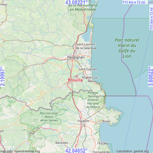
Brouilla GPS coordinates[2]
42° 33' 59.436" North, 2° 54' 11.124" East
| Map corner | latitude | longitude |
|---|---|---|
| Upper-left | 43.08221°, | 2.19997° |
| Center: | 42.56651°, | 2.90309° |
| Lower-right: | 42.04652°, | 3.60622° |
| Map W x H: | 115.2×115.2 km | = 71.6×71.6mi |
| max Lat: | 51.07786° ⇑99.4% North |
| Brouilla: | 42.56651° |
| min Lat: | ⇓0.6% South 41.3874° |
| min Long | Brouilla | max Long |
| -5.08615° | 2.90309° | 9.52242° |
| W 56.5%⇐ | ⇒43.5% E |
Elevation
Elevation of Brouilla is 46 m = 151 ft, and this is 147.7 m = 485 ft below average elevation for this country.
| Max E: |
2333 m = 7654 ft | 83.4% |
| Avg. | 193.7 m = 635 ft | |
| Brouilla | 46 m = 151 ft | |
Min E: |
-1 m = -3 ft | 16.6% |
See also: France elevation on elevation.city.
Geographical zone
Brouilla is located in North temperate zone (between Tropic of Cancer and the Arctic Circle). Distance of this Northern Tropic circle is 2127 km =1321.7 mi to South.| Distance of | km | miles | from Brouilla |
|---|---|---|---|
| North Pole | 5274.1 | 3277.2 | to North |
| Arctic Circle | 2668.2 | 1657.9 | to North |
| Tropic Cancer | 2127 | 1321.7 | to South |
| Equator | 4733 | 2940.9 | to South |


Nearby cities:
15 places around Brouilla: (largest is in red/bold)
• Bages
4.4 km =2.7 mi,  349°
349°
• Banyuls-dels-Aspres
3 km =1.9 mi,  268°
268°
• Elne
6.7 km =4.2 mi,  56°
56°
• Montescot
5.1 km =3.2 mi,  28°
28°
• Montesquiu d'Albera
5.7 km =3.5 mi,  197°
197°
• Ortaffa
2.4 km =1.5 mi,  52°
52°
• Palau-del-Vidre
4.7 km =2.9 mi,  83°
83°
• Saint-Génis-des-Fontaines
3 km =1.9 mi,  150°
150°
• Saint-Jean-Lasseille
3.4 km =2.1 mi,  300°
300°
• Sant Andreu de Sureda
5.8 km =3.6 mi,  106°
106°
• Sorède
6 km =3.7 mi,  132°
132°
• Tresserre
6 km =3.7 mi, 267°
• Vilallonga dels Monts
4.6 km =2.9 mi,  178°
178°
• Villemolaque
5.8 km =3.6 mi,  294°
294°
• la Roca d'Albera
5.6 km =3.5 mi, 153°
Sources, notices
• [Note1] Compared only with cities in France existing in our database
• [Src1] Map data: © OpenStreetMap contributors (CC-BY-SA)
• [Src2] Other city data from geonames.org with taken over terms of usage.
• [Src3] Geographical zone / Annual Mean Temperature by Robert A. Rohde @ Wikipedia
