Lent geodata
Lent (Auvergne-Rhône-Alpes) is a populated place; located in France in Europe/Paris (GMT+2) time zone. With population of 1,248 people, there are 7294 cities with bigger population in this country. Compared to other cities in France, 64.8% of cities are located further ↑North; 79.7% of cities are located further ←West and 75.9% of cities have lower elevation than Lent. Note1
Administrative division(s):
- Level 1: Auvergne-Rhône-Alpes
- Level 2: Département de l'Ain
- Level 3: Arrondissement de Bourg-en-Bresse
- Level 4: Lent


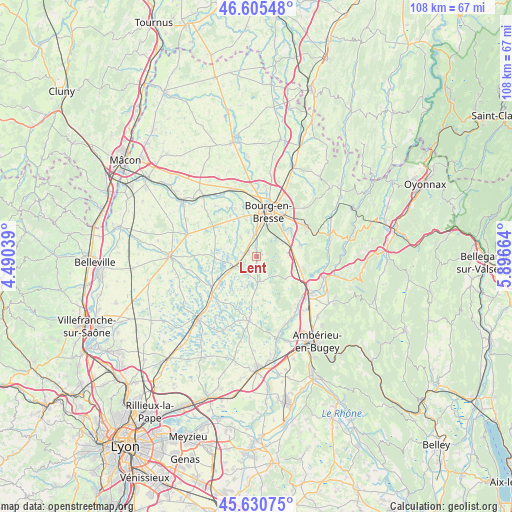
Lent GPS coordinates[2]
46° 7' 12.972" North, 5° 11' 36.672" East
| Map corner | latitude | longitude |
|---|---|---|
| Upper-left | 46.60548°, | 4.49039° |
| Center: | 46.12027°, | 5.19352° |
| Lower-right: | 45.63075°, | 5.89664° |
| Map W x H: | 108.4×108.4 km | = 67.4×67.4mi |
| max Lat: | 51.07786° ⇑64.8% North |
| Lent: | 46.12027° |
| min Lat: | ⇓35.2% South 41.3874° |
| min Long | Lent | max Long |
| -5.08615° | 5.19352° | 9.52242° |
| W 79.7%⇐ | ⇒20.3% E |
Elevation
Elevation of Lent is 256 m = 840 ft, and this is 62.3 m = 204 ft above average elevation for this country.
| Max E: |
2333 m = 7654 ft | 24.1% |
| Lent | 256 m 840 ft | |
| Avg. | 193.7 m = 635 ft | |
Min E: |
-1 m = -3 ft | 75.9% |
See also: France elevation on elevation.city.
Geographical zone
Lent is located in North temperate zone (between Tropic of Cancer and the Arctic Circle). Distance of this North polar circle is 2273.1 km =1412.4 mi to North.| Distance of | km | miles | from Lent |
|---|---|---|---|
| North Pole | 4879 | 3031.7 | to North |
| Arctic Circle | 2273.1 | 1412.4 | to North |
| Tropic Cancer | 2522.2 | 1567.2 | to South |
| Equator | 5128.1 | 3186.5 | to South |


Nearby cities:
15 places around Lent: (largest is in red/bold)
• Bourg-en-Bresse
9.8 km =6.1 mi,  14°
14°
• Certines
5.7 km =3.5 mi,  76°
76°
• Condeissiat
9.7 km =6 mi,  294°
294°
• Dompierre-sur-Veyle
5.5 km =3.4 mi,  172°
172°
• Montagnat
9 km =5.6 mi,  54°
54°
• Montracol
10.2 km =6.3 mi,  326°
326°
• Péronnas
7.1 km =4.4 mi, 10°
• Saint-André-sur-Vieux-Jonc
5.5 km =3.4 mi,  320°
320°
• Saint-Denis-lès-Bourg
9.1 km =5.7 mi,  357°
357°
• Saint-Martin-du-Mont
9.8 km =6.1 mi,  104°
104°
• Saint-Nizier-le-Désert
7.7 km =4.8 mi,  207°
207°
• Saint-Paul-de-Varax
5.6 km =3.5 mi,  242°
242°
• Saint-Rémy
8 km =5 mi,  344°
344°
• Servas
2.6 km =1.6 mi,  303°
303°
• Tossiat
9.3 km =5.8 mi, 76°
Sources, notices
• [Note1] Compared only with cities in France existing in our database
• [Src1] Map data: © OpenStreetMap contributors (CC-BY-SA)
• [Src2] Other city data from geonames.org with taken over terms of usage.
• [Src3] Geographical zone / Annual Mean Temperature by Robert A. Rohde @ Wikipedia
