Certines geodata
Certines (Auvergne-Rhône-Alpes) is a populated place; located in France in Europe/Paris (GMT+2) time zone. With population of 1,413 people, there are 6548 cities with bigger population in this country. Compared to other cities in France, 64.6% of cities are located further ↑North; 80.3% of cities are located further ←West and 74.8% of cities have lower elevation than Certines. Note1
Administrative division(s):
- Level 1: Auvergne-Rhône-Alpes
- Level 2: Département de l'Ain
- Level 3: Arrondissement de Bourg-en-Bresse
- Level 4: Certines


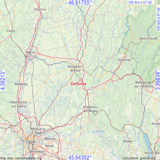
Certines GPS coordinates[2]
46° 7' 56.784" North, 5° 15' 54.9" East
| Map corner | latitude | longitude |
|---|---|---|
| Upper-left | 46.61755°, | 4.56213° |
| Center: | 46.13244°, | 5.26525° |
| Lower-right: | 45.64302°, | 5.96838° |
| Map W x H: | 108.4×108.4 km | = 67.4×67.4mi |
| max Lat: | 51.07786° ⇑64.6% North |
| Certines: | 46.13244° |
| min Lat: | ⇓35.4% South 41.3874° |
| min Long | Certines | max Long |
| -5.08615° | 5.26525° | 9.52242° |
| W 80.3%⇐ | ⇒19.7% E |
Elevation
Elevation of Certines is 247 m = 810 ft, and this is 53.3 m = 175 ft above average elevation for this country.
| Max E: |
2333 m = 7654 ft | 25.2% |
| Certines | 247 m 810 ft | |
| Avg. | 193.7 m = 635 ft | |
Min E: |
-1 m = -3 ft | 74.8% |
See also: France elevation on elevation.city.
Geographical zone
Certines is located in North temperate zone (between Tropic of Cancer and the Arctic Circle). Distance of this North polar circle is 2271.7 km =1411.6 mi to North.| Distance of | km | miles | from Certines |
|---|---|---|---|
| North Pole | 4877.6 | 3030.8 | to North |
| Arctic Circle | 2271.7 | 1411.6 | to North |
| Tropic Cancer | 2523.5 | 1568 | to South |
| Equator | 5129.4 | 3187.3 | to South |


Nearby cities:
15 places around Certines: (largest is in red/bold)
• Bohas-Meyriat-Rignat
10 km =6.2 mi,  72°
72°
• Bourg-en-Bresse
8.7 km =5.4 mi,  339°
339°
• Ceyzériat
6.9 km =4.3 mi,  37°
37°
• Dompierre-sur-Veyle
8.4 km =5.2 mi,  215°
215°
• Druillat
9.1 km =5.7 mi,  153°
153°
• Lent
5.7 km =3.5 mi,  256°
256°
• Montagnat
4.3 km =2.7 mi,  24°
24°
• Péronnas
7.1 km =4.4 mi,  323°
323°
• Revonnas
6.1 km =3.8 mi,  54°
54°
• Saint-André-sur-Vieux-Jonc
9.5 km =5.9 mi,  287°
287°
• Saint-Denis-lès-Bourg
9.7 km =6 mi, 322°
• Saint-Just
6.6 km =4.1 mi,  9°
9°
• Saint-Martin-du-Mont
5.5 km =3.4 mi,  133°
133°
• Servas
7.7 km =4.8 mi,  270°
270°
• Tossiat
3.7 km =2.3 mi,  77°
77°
Sources, notices
• [Note1] Compared only with cities in France existing in our database
• [Src1] Map data: © OpenStreetMap contributors (CC-BY-SA)
• [Src2] Other city data from geonames.org with taken over terms of usage.
• [Src3] Geographical zone / Annual Mean Temperature by Robert A. Rohde @ Wikipedia
