Tossiat geodata
Tossiat (Auvergne-Rhône-Alpes) is a populated place; located in France in Europe/Paris (GMT+2) time zone. With population of 1,231 people, there are 7376 cities with bigger population in this country. Compared to other cities in France, 64.5% of cities are located further ↑North; 80.7% of cities are located further ←West and 76.5% of cities have lower elevation than Tossiat. Note1
Administrative division(s):
- Level 1: Auvergne-Rhône-Alpes
- Level 2: Département de l'Ain
- Level 3: Arrondissement de Bourg-en-Bresse
- Level 4: Tossiat


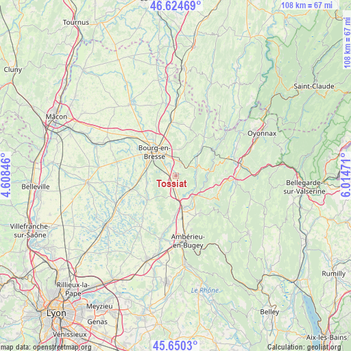
Tossiat GPS coordinates[2]
46° 8' 22.74" North, 5° 18' 41.688" East
| Map corner | latitude | longitude |
|---|---|---|
| Upper-left | 46.62469°, | 4.60846° |
| Center: | 46.13965°, | 5.31158° |
| Lower-right: | 45.6503°, | 6.01471° |
| Map W x H: | 108.3×108.3 km | = 67.3×67.3mi |
| max Lat: | 51.07786° ⇑64.5% North |
| Tossiat: | 46.13965° |
| min Lat: | ⇓35.5% South 41.3874° |
| min Long | Tossiat | max Long |
| -5.08615° | 5.31158° | 9.52242° |
| W 80.7%⇐ | ⇒19.3% E |
Elevation
Elevation of Tossiat is 260 m = 853 ft, and this is 66.3 m = 218 ft above average elevation for this country.
| Max E: |
2333 m = 7654 ft | 23.5% |
| Tossiat | 260 m 853 ft | |
| Avg. | 193.7 m = 635 ft | |
Min E: |
-1 m = -3 ft | 76.5% |
See also: France elevation on elevation.city.
Geographical zone
Tossiat is located in North temperate zone (between Tropic of Cancer and the Arctic Circle). Distance of this North polar circle is 2270.9 km =1411.1 mi to North.| Distance of | km | miles | from Tossiat |
|---|---|---|---|
| North Pole | 4876.8 | 3030.3 | to North |
| Arctic Circle | 2270.9 | 1411.1 | to North |
| Tropic Cancer | 2524.3 | 1568.5 | to South |
| Equator | 5130.2 | 3187.8 | to South |


Nearby cities:
15 places around Tossiat: (largest is in red/bold)
• Bohas-Meyriat-Rignat
6.3 km =3.9 mi,  69°
69°
• Certines
3.7 km =2.3 mi,  257°
257°
• Ceyzériat
4.7 km =2.9 mi,  7°
7°
• Druillat
9 km =5.6 mi,  177°
177°
• Hautecourt-Romanèche
8.5 km =5.3 mi, 74°
• Jasseron
8.2 km =5.1 mi, 7°
• Lent
9.3 km =5.8 mi, 256°
• Montagnat
3.6 km =2.2 mi,  329°
329°
• Neuville-sur-Ain
9 km =5.6 mi,  147°
147°
• Pont-d’Ain
9.6 km =6 mi,  166°
166°
• Péronnas
9.2 km =5.7 mi,  301°
301°
• Revonnas
3.1 km =1.9 mi,  26°
26°
• Saint-Just
6.3 km =3.9 mi,  336°
336°
• Saint-Martin-du-Mont
4.7 km =2.9 mi, 174°
• Villereversure
7.5 km =4.7 mi,  47°
47°
Sources, notices
• [Note1] Compared only with cities in France existing in our database
• [Src1] Map data: © OpenStreetMap contributors (CC-BY-SA)
• [Src2] Other city data from geonames.org with taken over terms of usage.
• [Src3] Geographical zone / Annual Mean Temperature by Robert A. Rohde @ Wikipedia
