Dompierre-sur-Veyle geodata
Dompierre-sur-Veyle (Auvergne-Rhône-Alpes) is a populated place; located in France in Europe/Paris (GMT+2) time zone. With population of 1,058 people, there are 8418 cities with bigger population in this country. Compared to other cities in France, 65.4% of cities are located further ↑North; 79.8% of cities are located further ←West and 79.3% of cities have lower elevation than Dompierre-sur-Veyle. Note1
Administrative division(s):
- Level 1: Auvergne-Rhône-Alpes
- Level 2: Département de l'Ain
- Level 3: Arrondissement de Bourg-en-Bresse
- Level 4: Dompierre-sur-Veyle


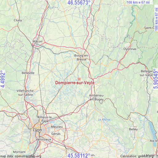
Dompierre-sur-Veyle GPS coordinates[2]
46° 4' 15.888" North, 5° 12' 8.352" East
| Map corner | latitude | longitude |
|---|---|---|
| Upper-left | 46.55673°, | 4.4992° |
| Center: | 46.07108°, | 5.20232° |
| Lower-right: | 45.58112°, | 5.90545° |
| Map W x H: | 108.5×108.5 km | = 67.4×67.4mi |
| max Lat: | 51.07786° ⇑65.4% North |
| Dompierre-sur-Veyle: | 46.07108° |
| min Lat: | ⇓34.6% South 41.3874° |
| min Long | Dompierre-sur-V | max Long |
| -5.08615° | 5.20232° | 9.52242° |
| W 79.8%⇐ | ⇒20.2% E |
Elevation
Elevation of Dompierre-sur-Veyle is 283 m = 928 ft, and this is 89.3 m = 293 ft above average elevation for this country.
| Max E: |
2333 m = 7654 ft | 20.7% |
| Dompierre-sur-Veyle | 283 m 928 ft | |
| Avg. | 193.7 m = 635 ft | |
Min E: |
-1 m = -3 ft | 79.3% |
See also: France elevation on elevation.city.
Geographical zone
Dompierre-sur-Veyle is located in North temperate zone (between Tropic of Cancer and the Arctic Circle). Distance of this North polar circle is 2278.6 km =1415.9 mi to North.| Distance of | km | miles | from Dompierre-sur-Veyle |
|---|---|---|---|
| North Pole | 4884.4 | 3035 | to North |
| Arctic Circle | 2278.6 | 1415.9 | to North |
| Tropic Cancer | 2516.7 | 1563.8 | to South |
| Equator | 5122.6 | 3183 | to South |


Nearby cities:
15 places around Dompierre-sur-Veyle: (largest is in red/bold)
• Certines
8.4 km =5.2 mi,  35°
35°
• Chalamont
8.6 km =5.3 mi,  197°
197°
• Châtillon-la-Palud
11.7 km =7.3 mi,  160°
160°
• Druillat
8.9 km =5.5 mi,  98°
98°
• Lent
5.5 km =3.4 mi,  352°
352°
• Marlieux
10.1 km =6.3 mi,  265°
265°
• Pont-d’Ain
10.7 km =6.6 mi, 99°
• Priay
10.1 km =6.3 mi,  139°
139°
• Péronnas
12.5 km =7.8 mi,  2°
2°
• Saint-André-sur-Vieux-Jonc
10.6 km =6.6 mi,  336°
336°
• Saint-Martin-du-Mont
9.3 km =5.8 mi,  71°
71°
• Saint-Nizier-le-Désert
4.4 km =2.7 mi,  252°
252°
• Saint-Paul-de-Varax
6.3 km =3.9 mi,  297°
297°
• Servas
7.5 km =4.7 mi, 337°
• Tossiat
11.4 km =7.1 mi,  47°
47°
Sources, notices
• [Note1] Compared only with cities in France existing in our database
• [Src1] Map data: © OpenStreetMap contributors (CC-BY-SA)
• [Src2] Other city data from geonames.org with taken over terms of usage.
• [Src3] Geographical zone / Annual Mean Temperature by Robert A. Rohde @ Wikipedia
