Le Molay-Littry geodata
Le Molay-Littry (Normandy) is a populated place; located in France in Europe/Paris (GMT+2) time zone. With population of 2,790 people, there are 3498 cities with bigger population in this country. Compared to other cities in France, 85% of cities are located further ↓South; 87.1% of cities are located further →East and 84.1% of cities have higher elevation than Le Molay-Littry. Note1
Administrative division(s):
- Level 1: Normandy
- Level 2: Calvados
- Level 3: Arrondissement de Bayeux
- Level 4: Le Molay-Littry


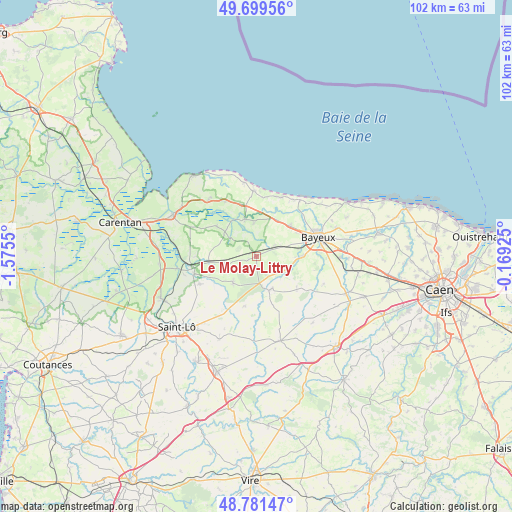
Le Molay-Littry GPS coordinates[2]
49° 14' 33.54" North, 0° 52' 20.568" West
| Map corner | latitude | longitude |
|---|---|---|
| Upper-left | 49.69956°, | -1.5755° |
| Center: | 49.24265°, | -0.87238° |
| Lower-right: | 48.78147°, | -0.16925° |
| Map W x H: | 102.1×102.1 km | = 63.4×63.4mi |
| max Lat: | 51.07786° ⇑15% North |
| Le Molay-Littry: | 49.24265° |
| min Lat: | ⇓85% South 41.3874° |
| min Long | Le Molay-Littry | max Long |
| -5.08615° | -0.87238° | 9.52242° |
| W 12.9%⇐ | ⇒87.1% E |
Elevation
Elevation of Le Molay-Littry is 44 m = 144 ft, and this is 149.7 m = 491 ft below average elevation for this country.
| Max E: |
2333 m = 7654 ft | 84.1% |
| Avg. | 193.7 m = 635 ft | |
| Le Molay-Littry | 44 m = 144 ft | |
Min E: |
-1 m = -3 ft | 15.9% |
See also: France elevation on elevation.city.
Geographical zone
Le Molay-Littry is located in North temperate zone (between Tropic of Cancer and the Arctic Circle). Distance of this North polar circle is 1925.9 km =1196.7 mi to North.| Distance of | km | miles | from Le Molay-Littry |
|---|---|---|---|
| North Pole | 4531.8 | 2815.9 | to North |
| Arctic Circle | 1925.9 | 1196.7 | to North |
| Tropic Cancer | 2869.4 | 1783 | to South |
| Equator | 5475.3 | 3402.2 | to South |


Nearby cities:
15 places around Le Molay-Littry: (largest is in red/bold)
• Balleroy
7.3 km =4.5 mi,  159°
159°
• Bayeux
12.8 km =8 mi,  72°
72°
• Cerisy-la-Forêt
7.1 km =4.4 mi,  221°
221°
• Juaye-Mondaye
13.2 km =8.2 mi,  104°
104°
• La Cambe
14.8 km =9.2 mi,  319°
319°
• Le Tronquay
4.2 km =2.6 mi,  116°
116°
• Moon-sur-Elle
13.4 km =8.3 mi,  252°
252°
• Port-en-Bessin-Huppain
14.2 km =8.8 mi,  36°
36°
• Saint-Clair-sur-l'Elle
12.7 km =7.9 mi,  243°
243°
• Saint-Martin-des-Entrées
14.8 km =9.2 mi,  79°
79°
• Saint-Paul-du-Vernay
10.1 km =6.3 mi,  126°
126°
• Saint-Vigor-le-Grand
14.2 km =8.8 mi, 71°
• Subles
8.8 km =5.5 mi,  91°
91°
• Tour-en-Bessin
9.2 km =5.7 mi,  48°
48°
• Trévières
7.7 km =4.8 mi,  342°
342°
Sources, notices
• [Note1] Compared only with cities in France existing in our database
• [Src1] Map data: © OpenStreetMap contributors (CC-BY-SA)
• [Src2] Other city data from geonames.org with taken over terms of usage.
• [Src3] Geographical zone / Annual Mean Temperature by Robert A. Rohde @ Wikipedia
