Leers geodata
Leers (Hauts-de-France) is a populated place; located in France in Europe/Paris (GMT+2) time zone. With population of 9,823 people, there are 968 cities with bigger population in this country. Compared to other cities in France, 98.7% of cities are located further ↓South; 61.2% of cities are located further ←West and 89.9% of cities have higher elevation than Leers. Note1
Administrative division(s):
- Level 1: Hauts-de-France
- Level 2: Nord
- Level 3: Arrondissement de Lille
- Level 4: Leers


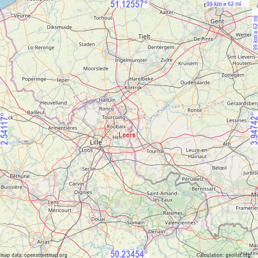
Leers GPS coordinates[2]
50° 40' 55.812" North, 3° 14' 39.444" East
| Map corner | latitude | longitude |
|---|---|---|
| Upper-left | 51.12557°, | 2.54117° |
| Center: | 50.68217°, | 3.24429° |
| Lower-right: | 50.23454°, | 3.94742° |
| Map W x H: | 99.1×99.1 km | = 61.6×61.6mi |
| max Lat: | 51.07786° ⇑1.3% North |
| Leers: | 50.68217° |
| min Lat: | ⇓98.7% South 41.3874° |
| min Long | Leers | max Long |
| -5.08615° | 3.24429° | 9.52242° |
| W 61.2%⇐ | ⇒38.8% E |
Elevation
Elevation of Leers is 30 m = 98 ft, and this is 163.7 m = 537 ft below average elevation for this country.
| Max E: |
2333 m = 7654 ft | 89.9% |
| Avg. | 193.7 m = 635 ft | |
| Leers | 30 m = 98 ft | |
Min E: |
-1 m = -3 ft | 10.1% |
See also: France elevation on elevation.city.
Geographical zone
Leers is located in North temperate zone (between Tropic of Cancer and the Arctic Circle). Distance of this North polar circle is 1765.8 km =1097.2 mi to North.| Distance of | km | miles | from Leers |
|---|---|---|---|
| North Pole | 4371.7 | 2716.4 | to North |
| Arctic Circle | 1765.8 | 1097.2 | to North |
| Tropic Cancer | 3029.4 | 1882.4 | to South |
| Equator | 5635.3 | 3501.6 | to South |


Nearby cities:
15 places around Leers: (largest is in red/bold)
• Baisieux
8.2 km =5.1 mi,  175°
175°
• Croix
6.7 km =4.2 mi,  266°
266°
• Forest-sur-Marque
6.7 km =4.2 mi,  215°
215°
• Hem
5.2 km =3.2 mi,  230°
230°
• Lannoy
3 km =1.9 mi, 234°
• Lys-lez-Lannoy
2.6 km =1.6 mi, 228°
• Mouvaux
8 km =5 mi,  283°
283°
• Roubaix
5.1 km =3.2 mi,  285°
285°
• Sailly-lez-Lannoy
4.1 km =2.5 mi,  208°
208°
• Toufflers
2.5 km =1.6 mi,  197°
197°
• Tourcoing
7.5 km =4.7 mi,  308°
308°
• Tressin
8 km =5 mi, 206°
• Wasquehal
7.9 km =4.9 mi,  260°
260°
• Wattrelos
2.8 km =1.7 mi,  318°
318°
• Willems
5.6 km =3.5 mi, 184°
Sources, notices
• [Note1] Compared only with cities in France existing in our database
• [Src1] Map data: © OpenStreetMap contributors (CC-BY-SA)
• [Src2] Other city data from geonames.org with taken over terms of usage.
• [Src3] Geographical zone / Annual Mean Temperature by Robert A. Rohde @ Wikipedia
