Lys-lez-Lannoy geodata
Lys-lez-Lannoy (Hauts-de-France) is a populated place; located in France in Europe/Paris (GMT+2) time zone. With population of 13,803 people, there are 688 cities with bigger population in this country. Compared to other cities in France, 98.6% of cities are located further ↓South; 60.8% of cities are located further ←West and 88.6% of cities have higher elevation than Lys-lez-Lannoy. Note1
Administrative division(s):
- Level 1: Hauts-de-France
- Level 2: Nord
- Level 3: Arrondissement de Lille
- Level 4: Lys-lez-Lannoy


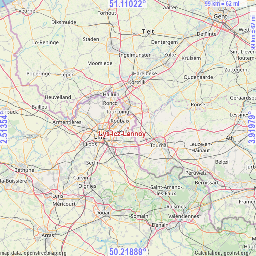
Lys-lez-Lannoy GPS coordinates[2]
50° 40' 0.012" North, 3° 13' 0.012" East
| Map corner | latitude | longitude |
|---|---|---|
| Upper-left | 51.11022°, | 2.51354° |
| Center: | 50.66667°, | 3.21667° |
| Lower-right: | 50.21889°, | 3.91979° |
| Map W x H: | 99.1×99.1 km | = 61.6×61.6mi |
| max Lat: | 51.07786° ⇑1.4% North |
| Lys-lez-Lannoy: | 50.66667° |
| min Lat: | ⇓98.6% South 41.3874° |
| min Long | Lys-lez-Lannoy | max Long |
| -5.08615° | 3.21667° | 9.52242° |
| W 60.8%⇐ | ⇒39.2% E |
Elevation
Elevation of Lys-lez-Lannoy is 33 m = 108 ft, and this is 160.7 m = 527 ft below average elevation for this country.
| Max E: |
2333 m = 7654 ft | 88.6% |
| Avg. | 193.7 m = 635 ft | |
| Lys-lez-Lannoy | 33 m = 108 ft | |
Min E: |
-1 m = -3 ft | 11.4% |
See also: France elevation on elevation.city.
Geographical zone
Lys-lez-Lannoy is located in North temperate zone (between Tropic of Cancer and the Arctic Circle). Distance of this North polar circle is 1767.6 km =1098.3 mi to North.| Distance of | km | miles | from Lys-lez-Lannoy |
|---|---|---|---|
| North Pole | 4373.5 | 2717.6 | to North |
| Arctic Circle | 1767.6 | 1098.3 | to North |
| Tropic Cancer | 3027.7 | 1881.3 | to South |
| Equator | 5633.6 | 3500.6 | to South |


Nearby cities:
15 places around Lys-lez-Lannoy: (largest is in red/bold)
• Chéreng
6.3 km =3.9 mi,  186°
186°
• Croix
4.9 km =3 mi,  285°
285°
• Forest-sur-Marque
4.2 km =2.6 mi,  207°
207°
• Hem
2.6 km =1.6 mi,  233°
233°
• Lannoy
0.5 km =0.3 mi,  270°
270°
• Leers
2.6 km =1.6 mi,  48°
48°
• Mouvaux
6.9 km =4.3 mi,  302°
302°
• Roubaix
4.3 km =2.7 mi,  315°
315°
• Sailly-lez-Lannoy
1.9 km =1.2 mi,  180°
180°
• Toufflers
1.4 km =0.9 mi,  120°
120°
• Tressin
5.7 km =3.5 mi,  196°
196°
• Villeneuve-d'Ascq
6.6 km =4.1 mi, 212°
• Wasquehal
5.9 km =3.7 mi, 274°
• Wattrelos
3.8 km =2.4 mi,  1°
1°
• Willems
4.1 km =2.5 mi,  158°
158°
Sources, notices
• [Note1] Compared only with cities in France existing in our database
• [Src1] Map data: © OpenStreetMap contributors (CC-BY-SA)
• [Src2] Other city data from geonames.org with taken over terms of usage.
• [Src3] Geographical zone / Annual Mean Temperature by Robert A. Rohde @ Wikipedia
