Lécluse geodata
Lécluse (Hauts-de-France) is a populated place; located in France in Europe/Paris (GMT+2) time zone. With population of 1,622 people, there are 5756 cities with bigger population in this country. Compared to other cities in France, 95.3% of cities are located further ↓South; 58.4% of cities are located further ←West and 84.5% of cities have higher elevation than Lécluse. Note1
Administrative division(s):
- Level 1: Hauts-de-France
- Level 2: Nord
- Level 3: Arrondissement de Douai
- Level 4: Lécluse


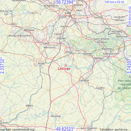
Lécluse GPS coordinates[2]
50° 16' 36.156" North, 3° 2' 25.62" East
| Map corner | latitude | longitude |
|---|---|---|
| Upper-left | 50.72394°, | 2.33732° |
| Center: | 50.27671°, | 3.04045° |
| Lower-right: | 49.82523°, | 3.74357° |
| Map W x H: | 99.9×99.9 km | = 62.1×62.1mi |
| max Lat: | 51.07786° ⇑4.7% North |
| Lécluse: | 50.27671° |
| min Lat: | ⇓95.3% South 41.3874° |
| min Long | Lécluse | max Long |
| -5.08615° | 3.04045° | 9.52242° |
| W 58.4%⇐ | ⇒41.6% E |
Elevation
Elevation of Lécluse is 43 m = 141 ft, and this is 150.7 m = 494 ft below average elevation for this country.
| Max E: |
2333 m = 7654 ft | 84.5% |
| Avg. | 193.7 m = 635 ft | |
| Lécluse | 43 m = 141 ft | |
Min E: |
-1 m = -3 ft | 15.5% |
See also: France elevation on elevation.city.
Geographical zone
Lécluse is located in North temperate zone (between Tropic of Cancer and the Arctic Circle). Distance of this North polar circle is 1810.9 km =1125.2 mi to North.| Distance of | km | miles | from Lécluse |
|---|---|---|---|
| North Pole | 4416.8 | 2744.5 | to North |
| Arctic Circle | 1810.9 | 1125.2 | to North |
| Tropic Cancer | 2984.3 | 1854.4 | to South |
| Equator | 5590.2 | 3473.6 | to South |


Nearby cities:
15 places around Lécluse: (largest is in red/bold)
• Arleux
4.6 km =2.9 mi,  84°
84°
• Brebières
6.5 km =4 mi,  344°
344°
• Corbehem
6.1 km =3.8 mi,  6°
6°
• Estrées
3.4 km =2.1 mi,  37°
37°
• Férin
6.1 km =3.8 mi,  23°
23°
• Gouy-sous-Bellonne
4 km =2.5 mi, 16°
• Gœulzin
6.1 km =3.8 mi, 43°
• Hamel
2.4 km =1.5 mi, 82°
• Noyelles-sous-Bellonne
3.6 km =2.2 mi,  345°
345°
• Oisy-le-Verger
6.6 km =4.1 mi,  116°
116°
• Palluel
4.1 km =2.5 mi,  114°
114°
• Rumaucourt
4 km =2.5 mi,  159°
159°
• Sailly-en-Ostrevent
3.7 km =2.3 mi,  291°
291°
• Tortequesne
1.4 km =0.9 mi,  357°
357°
• Écourt-Saint-Quentin
3.6 km =2.2 mi,  139°
139°
Sources, notices
• [Note1] Compared only with cities in France existing in our database
• [Src1] Map data: © OpenStreetMap contributors (CC-BY-SA)
• [Src2] Other city data from geonames.org with taken over terms of usage.
• [Src3] Geographical zone / Annual Mean Temperature by Robert A. Rohde @ Wikipedia
