Oisy-le-Verger geodata
Oisy-le-Verger (Hauts-de-France) is a populated place; located in France in Europe/Paris (GMT+2) time zone. With population of 1,292 people, there are 7073 cities with bigger population in this country. Compared to other cities in France, 95.1% of cities are located further ↓South; 59.5% of cities are located further ←West and 71% of cities have higher elevation than Oisy-le-Verger. Note1
Administrative division(s):
- Level 1: Hauts-de-France
- Level 2: Pas-de-Calais
- Level 3: Arras
- Level 4: Oisy-le-Verger


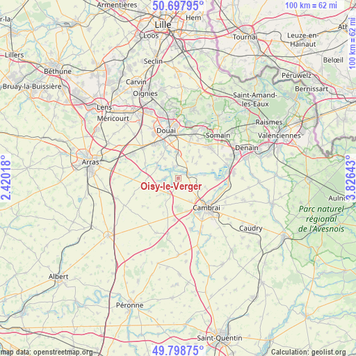
Oisy-le-Verger GPS coordinates[2]
50° 15' 1.692" North, 3° 7' 23.88" East
| Map corner | latitude | longitude |
|---|---|---|
| Upper-left | 50.69795°, | 2.42018° |
| Center: | 50.25047°, | 3.1233° |
| Lower-right: | 49.79875°, | 3.82643° |
| Map W x H: | 100×100 km | = 62.1×62.1mi |
| max Lat: | 51.07786° ⇑4.9% North |
| Oisy-le-Verger: | 50.25047° |
| min Lat: | ⇓95.1% South 41.3874° |
| min Long | Oisy-le-Verger | max Long |
| -5.08615° | 3.1233° | 9.52242° |
| W 59.5%⇐ | ⇒40.5% E |
Elevation
Elevation of Oisy-le-Verger is 76 m = 249 ft, and this is 117.7 m = 386 ft below average elevation for this country.
| Max E: |
2333 m = 7654 ft | 71% |
| Avg. | 193.7 m = 635 ft | |
| Oisy-le-Verger | 76 m = 249 ft | |
Min E: |
-1 m = -3 ft | 29% |
See also: France elevation on elevation.city.
Geographical zone
Oisy-le-Verger is located in North temperate zone (between Tropic of Cancer and the Arctic Circle). Distance of this North polar circle is 1813.8 km =1127 mi to North.| Distance of | km | miles | from Oisy-le-Verger |
|---|---|---|---|
| North Pole | 4419.7 | 2746.3 | to North |
| Arctic Circle | 1813.8 | 1127 | to North |
| Tropic Cancer | 2981.4 | 1852.6 | to South |
| Equator | 5587.3 | 3471.8 | to South |


Nearby cities:
15 places around Oisy-le-Verger: (largest is in red/bold)
• Arleux
3.6 km =2.2 mi,  338°
338°
• Aubencheul-au-Bac
2.6 km =1.6 mi,  74°
74°
• Aubigny-au-Bac
3.3 km =2.1 mi,  63°
63°
• Bugnicourt
5.1 km =3.2 mi,  26°
26°
• Cantin
6.5 km =4 mi,  2°
2°
• Fressain
6.5 km =4 mi,  50°
50°
• Fressies
5.1 km =3.2 mi,  83°
83°
• Féchain
6.4 km =4 mi, 74°
• Hamel
4.7 km =2.9 mi,  312°
312°
• Haynecourt
5.3 km =3.3 mi,  151°
151°
• Lécluse
6.6 km =4.1 mi,  296°
296°
• Marquion
5.1 km =3.2 mi,  210°
210°
• Palluel
2.5 km =1.6 mi, 299°
• Rumaucourt
4.6 km =2.9 mi,  259°
259°
• Écourt-Saint-Quentin
3.6 km =2.2 mi,  273°
273°
Sources, notices
• [Note1] Compared only with cities in France existing in our database
• [Src1] Map data: © OpenStreetMap contributors (CC-BY-SA)
• [Src2] Other city data from geonames.org with taken over terms of usage.
• [Src3] Geographical zone / Annual Mean Temperature by Robert A. Rohde @ Wikipedia
