Corbehem geodata
Corbehem (Hauts-de-France) is a populated place; located in France in Europe/Paris (GMT+2) time zone. With population of 2,355 people, there are 4103 cities with bigger population in this country. Compared to other cities in France, 95.9% of cities are located further ↓South; 58.5% of cities are located further ←West and 88.6% of cities have higher elevation than Corbehem. Note1
Administrative division(s):
- Level 1: Hauts-de-France
- Level 2: Pas-de-Calais
- Level 3: Arras
- Level 4: Corbehem


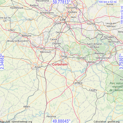
Corbehem GPS coordinates[2]
50° 19' 53.076" North, 3° 2' 59.82" East
| Map corner | latitude | longitude |
|---|---|---|
| Upper-left | 50.77813°, | 2.34682° |
| Center: | 50.33141°, | 3.04995° |
| Lower-right: | 49.88045°, | 3.75307° |
| Map W x H: | 99.8×99.8 km | = 62×62mi |
| max Lat: | 51.07786° ⇑4.1% North |
| Corbehem: | 50.33141° |
| min Lat: | ⇓95.9% South 41.3874° |
| min Long | Corbehem | max Long |
| -5.08615° | 3.04995° | 9.52242° |
| W 58.5%⇐ | ⇒41.5% E |
Elevation
Elevation of Corbehem is 33 m = 108 ft, and this is 160.7 m = 527 ft below average elevation for this country.
| Max E: |
2333 m = 7654 ft | 88.6% |
| Avg. | 193.7 m = 635 ft | |
| Corbehem | 33 m = 108 ft | |
Min E: |
-1 m = -3 ft | 11.4% |
See also: France elevation on elevation.city.
Geographical zone
Corbehem is located in North temperate zone (between Tropic of Cancer and the Arctic Circle). Distance of this North polar circle is 1804.8 km =1121.5 mi to North.| Distance of | km | miles | from Corbehem |
|---|---|---|---|
| North Pole | 4410.7 | 2740.7 | to North |
| Arctic Circle | 1804.8 | 1121.5 | to North |
| Tropic Cancer | 2990.4 | 1858.1 | to South |
| Equator | 5596.3 | 3477.4 | to South |


Nearby cities:
15 places around Corbehem: (largest is in red/bold)
• Brebières
2.4 km =1.5 mi,  275°
275°
• Courchelettes
1.2 km =0.7 mi,  33°
33°
• Cuincy
5.3 km =3.3 mi,  2°
2°
• Dechy
5.2 km =3.2 mi,  66°
66°
• Douai
4.8 km =3 mi, 25°
• Esquerchin
5.5 km =3.4 mi,  332°
332°
• Estrées
3.7 km =2.3 mi,  157°
157°
• Férin
1.8 km =1.1 mi,  104°
104°
• Gouy-sous-Bellonne
2.3 km =1.4 mi,  168°
168°
• Gœulzin
3.9 km =2.4 mi,  114°
114°
• Hamel
6 km =3.7 mi, 163°
• Lambres-lez-Douai
2.4 km =1.5 mi, 29°
• Noyelles-sous-Bellonne
3 km =1.9 mi,  211°
211°
• Tortequesne
4.8 km =3 mi,  188°
188°
• Vitry-en-Artois
5 km =3.1 mi,  263°
263°
Sources, notices
• [Note1] Compared only with cities in France existing in our database
• [Src1] Map data: © OpenStreetMap contributors (CC-BY-SA)
• [Src2] Other city data from geonames.org with taken over terms of usage.
• [Src3] Geographical zone / Annual Mean Temperature by Robert A. Rohde @ Wikipedia
